
Key takeaways
- Built by surveyors for surveyors, with a complete and practical photogrammetry workflow
- Supports major data sources including drones, LiDAR, GNSS, SLAM, and more within one platform
- Includes the Scan Module for merging and processing point clouds
- Features RTK Videogrammetry for creating accurate 3D models from phone videos
- Comes with 3Dsurvey Cloud for simple project and data sharing
- Supported by a global network of 70+ partners worldwide
- Designed for efficiency, accuracy, and real-world surveying workflows
Introduction
The photogrammetry world in 2026 is full of bloated platforms, hidden costs, and tools built for demos – not real work. 3Dsurvey takes a different path. Built by land surveyors in Europe, it offers a clean, modular, and professional solution that delivers exactly what you need – from drone data, cameras and even smartphones, to CAD-ready deliverables, without locking you into overpriced ecosystems. Here’s why thousands of our users believe it is the best photogrammetry software in 2026 and it’s become the go-to platform for professionals worldwide.
Only surveyors can build the best photogrammetry software in 2026
3Dsurvey wasn’t imagined in a boardroom, it was built in the field. The people behind it are surveyors who got tired of wasting time with software that looked impressive but didn’t help get the job done. That’s why everything in 3Dsurvey, from the interface to the tools, is shaped around how real projects work, not how someone thinks they work.
It’s made for teams who work on land surveying, construction sites, mining areas, and infrastructure projects. If you want to further understand which challenges the construction industry is facing today and how 3Dsurvey can help with that, we invite you to read more in our blog. The main point stays the same: the workflows in 3Dsurvey are practical, so they fit the way you already work, instead of forcing you to change everything.
What features does the best photogrammetry software in 2026 need to offer?
Every tool in 3Dsurvey is there for a reason. It’s not built to impress with long feature lists, but to solve problems in the field. Although we must admit, the features list is impressive.
It’s also proven. Professionals in more than 35 countries all over the world already rely on it. You’re not joining an experiment – you’re joining a global community of people who use it every day and get results.
It’s not about being flashy. It’s about getting the job done – right, fast, and reliably. That’s what we think the best photogrammetry software in 2026 should do.
All-in-one software, but make it modular and flexible
3Dsurvey gives you the full workflow in one place- and not just for photogrammetry. Whether you’re working with drone images, LiDAR scans, SLAM point clouds, or even sonar data, it’s built to handle all of it. And everything is modular, so you only pay for the parts you actually use. No forced upgrades, no bundled extras you’ll never touch.
Would you like to add modules?
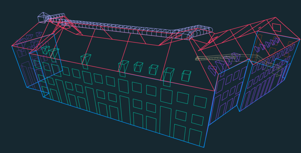
The Scan module is there when you need to push your point clouds to the next level and extract hidden information from them.. It includes automatic line detection, lets you register clouds manually or automatically, enables you to inspect through spherical images, gives you tools to visualize the buildings like X-ray scans, all that with full CAD drawing support. Whether the data came from a drone, a handheld SLAM device, or a terrestrial scanner- you can get clean vector lines out fast. Huge time saver if you’re preparing for CAD.
If you prefer to shoot video instead of hundreds of stills, the RTK Videogrammetry module lets you process that footage. It extracts georeferenced frames and builds usable models. Great for fast mapping, inspections, or field jobs where time is tight.
Everything, from importing raw data to drawing lines, happens in one place. You stay focused, you work faster, and you stay in control.
Full workflow control, no vendor lock-in
3Dsurvey works with any drone or scanner — DJI, Sony, Parrot, LiDAR, SLAM, and more. You’re never locked into a brand or forced to replace your hardware.
Process as much data as your PC can handle — no image caps, no hidden fees, no cloud required. From small sites to full corridors, it runs locally without limits. It supports open formats like LAS, LAZ, E57, DXF, SHP, TIFF, OBJ, and more — making collaboration with clients and contractors simple.
Prefer ownership? Go for a perpetual license: one-time payment, no forced renewals, and optional upgrades only if you want them.
Most importantly, your data stays yours. No tracking, no uploads, no lock-in. That’s what sets the best photogrammetry software in 2026 apart: full control over your tools and your results.
Data integration – a platform that fits your tools, not the other way around
3Dsurvey fits into your workflow not the other way around. It supports data from drones and DSLR cameras, so you can keep capturing the way you always have. No need to change hardware.
LiDAR data from mobile or static scanners is fully supported – great for mapping elevation in forests, quarries, or complex terrain. You can find more information about that in this case study.
SLAM mappers are covered too, making indoor or underground scanning possible without GPS. We went into details about this in our Floor Plan Extraction with Automated Line Detection webinar.
You can also bring in sonar data for underwater mapping, which is useful in coastal zones, dam sites, or lakebeds. Read how our partner tackled this in another case study.
Do you want fast, flexible data capture? 3Dsurvey supports RTK Videogrammetry. Why would you need RTK Videogrammetry for 3D model creation? Find out in this case study. Pair your Android phone with RTK GNSS, record the video with a phone, and get thousands of georeferenced frames in one smooth walk-through. Ideal for shafts, smaller sites, and linear structures. It’s fast, simple, and accurate where traditional photogrammetry falls short due to limitations (drone flight restrictions, no trained pilot on site, hard to access).
Supported inputs include JPEG, MP4, LAS, LAZ, E57, XYZ, OBJ, and TXT. Just load mixed datasets into a single project and get to work – no conversions needed.
Integrated CAD tools: draw, snap, and vectorize with precision
Collecting data is only half the job. What matters most is what you can do with it and how quickly. That’s why 3Dsurvey includes integrated CAD tools built specifically for surveyors. If you want to learn how to use Integrated CAD functions in 3Dsurvey, we recommend you watch this tutorial.
You can draw directly onto your 3D model, using smart snapping to points, edges, and intersections, which makes precision work faster, even in dense datasets. You’re not just sketching, you’re drawing usable geometry, without needing to redo it later in AutoCAD. You have guessed it! We also have a tutorial on how to use the snapper settings in CAD.
3Dsurvey’s integrated CAD engine is more than just a simple line and measurement gimmick you may find in other similar softwares. As the only one on the market, 3Dsurvey offers plane lock and perpendicular line drawing for unmatched precision drawing. With the list of CAD features, which is honestly too long for this blog post, 3Dsurvey will not let down even the most advanced CAD users. You can read more about Mastering CAD here.
Need to follow slope rules or angle limits? Real-time measurements are shown as you work, so you always know if your feature matches the spec, whether it’s a road edge, drainage line, or embankment.
Your lines are organized in layers, so when it’s time to export to DXF or SHP, everything is structured and ready to go. No manual sorting, no CAD clean-up.
You can also reshape polylines as you go. It means you finish your drawings inside one tool, instead of spending hours fixing them in another.
This is also one of the reasons why 3Dsurvey is a beginner-friendly software. If you’re interested to know all of them, read our blog on Best photogrammetry software for beginners.
Data extraction: deliverables that matter
3Dsurvey turns photos and point clouds into the kinds of outputs professionals actually use: clean, clear, and ready to deliver. What is point cloud? Find your answer here.
You can generate smooth, readable contours in just a few clicks. That is ideal for:
- planning,
- design approvals, or
- permitting.
Cross-sections can be cut along any path, letting you extract terrain profiles for roads, trenches, or any corridor that matters. Want to learn how to work with point cloud editing tools efficiently? Then you have to take a look at our tutorial.
Volume calculations are precise and fast, whether you’re measuring cut/fill for earthworks or estimating stockpiles for billing. Digital Terrain Models (DTMs) include semi-automatic ground classification, so you can strip out trees and buildings and work with the true surface underneath. Want to get ahead of competition? Read more on that in our case study.
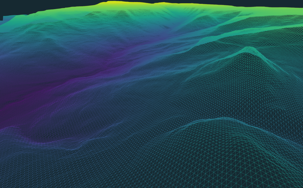
Track changes over time with surface comparison tools—ideal for progress reports, construction monitoring, or inspections. Colorize by elevation, slope, or intensity to help clients instantly understand the data. Export to standard formats like DXF, SHP, PDF, XYZ, TIFF, PLY, and OBJ for easy use in CAD, GIS, or regulatory systems. When you’re done, generate full reports with one click.
The best photogrammetry software in 2026? It delivers clear, professional results your clients can open, understand, and trust—no extra help needed.
Easy result sharing: Cloud Viewer with client-friendly delivery
Getting results is one thing, delivering them in a way clients can actually use is another. With 3Dsurvey’s built-in cloud viewer, you can share orthophotos, 3D models, point clouds and CAD directly through a web link. No special software, no installs – clients just click and view. How? Check our webinar.
Cloud Sharing option helps with:
Showing project stages side by side to easily track progress over time — perfect for construction updates, site changes, or inspections.
Showing visual results, no explanation needed — just open, see, and understand.
Organizing projects by location and date, ideal for long-term or recurring work.
Adding annotations and adjusting views as needed.
It can:
- Work in any browser, on any device — no logins, no downloads, no barriers.
Be included with your annual updates and support — no extra cost.
That’s what the best photogrammetry software in 2026 should deliver — and what 3Dsurvey already does.

Transparent licensing
3Dsurvey’s licensing is simple and honest—designed to fit how real businesses operate.
You can choose a perpetual license and own the software forever. No forced renewals, no ticking clocks, just long-term access that fits the way real businesses operate. When you want to stay on the latest version, the optional Upgrade & Support package gives you updates, new features, and expert help but only when you choose it.
Licensing is modular too. You only pay for the parts of the software that actually bring value to your work, whether it’s the core photogrammetry, Scan module, or RTK Videogrammetry. No bundling tricks and no wasted budget.
Real support from real surveyors
When you’re on-site or racing a deadline, you don’t need manuals or call centers—you need people who understand the job. That’s why 3Dsurvey’s support team is made up of experienced surveyors who’ve used the software in the field.
If you choose a perpetual license, onboarding is included from day one. You get help with setup, best practices, and avoiding common mistakes. With the Upgrade & Support plan, you get ongoing updates and expert help whenever needed.
Stuck on a tough dataset or a high-stakes project? You can even get help with processing—whether it’s advice or hands-on support:
Support available in 18 languages
Fast, direct responses from actual experts
This isn’t just support—it’s real backup from people who’ve done the work.
Linux Beta Support
3Dsurvey is now available natively on Linux, bringing professional Linux photogrammetry software to Ubuntu and other Linux distributions. Users can process drone imagery, LiDAR, point clouds, orthophotos, and CAD-ready deliverables with the same core engine and output quality available on Windows — no Wine or virtual machine required.
The Linux release includes the full photogrammetry workflow, built-in CAD tools, cloud sharing, and support for modern surveying data sources, making it a powerful all-in-one solution for geospatial professionals.
You can read more about the Linux version in our blog.
Conclusion: 3Dsurvey sets the standard for best photogrammetry software in 2026
3Dsurvey is more than just a photogrammetry software — it’s a complete, no-fuss workflow solution built by surveyors for surveyors. Designed from real-world experience and trusted in over 70 countries, it offers full workflow control, flexible licensing, hardware freedom, and professional-grade outputs without gimmicks or surprises. Just reliable software that gets the job done right.
This is why for thousands of professionals who know the difference, 3Dsurvey is the best photogrammetry software in 2026.
Don’t believe us and you want to see it for yourself? Sign up for our 14-day free trial now.
Want to understand more about how does a photogrammetry software work? Find out here. Or you can go to our comparison review of the Top photogrammetry software for drone mapping and see for yourself.

