Integrated CAD engine
The design of the CAD module in 3Dsurvey is tailored to meet the needs of users familiar with industry-standard drafting tools, promising an intuitive experience. You can snap on point cloud, mesh surface, endpoints, midpoints and all other standard CAD elements, ensuring consistency across projects.
3Dsurvey lets you get rid of multiple programs for your photogrammetry and CAD needs. It provides you with one easy-to-use platform, enabling straightforward transition from creating 3D models to drawing CAD elements.
3Dsurvey supports a complete layers system for an easy integration of existing workflow. If you have a preferred layer preset in your standard workflow, simply import your DXF file with empty layers and continue working – it saves time and ensures consistency!
Regardless of project’s complexity, 3Dsurvey enables you to combine lines, polylines, survey points, contour lines, and closed polygons, facilitating the creation of survey maps in both 2D and 3D. Your mapping needs are therefore completely covered!
Export your CAD results to any location in virtually any format you need, when you're done.
Volume calculation
Plan and measure your projects with ease. Built-in accuracy for superb control of the site, regardless of previously used software or type of measurements. Compare multiple measurements, visualize in realistic 3D detail, and detect changes on the fly or over time.

Whether you're working with volume calculation of a single surface, comparing measurements of two different surfaces, or integrating a photogrammetry surface with a design surface, 3Dsurvey is flexible enough to handle various scenarios – including designs created within 3Dsurvey or imported from third-party software.
3Dsurvey is among the few that fill the gap between the traditional surveying approach and ''modern'' photogrammetry approach. You can easily do a volumetric comparison of a measurement done with traditional equipment (total station and GNSS device) with a measurement measured with a drone.
Say goodbye to the cumbersome process of exporting and importing data between different programs. Perform all your volumetric tasks within a single platform.
Profile lines and cross sections
Better understand your terrain and simplify the process with automatic generation of precise 3D profiles.
Understanding the details of the terrain is crucial for professionals in surveying, construction, mining, environmental monitoring, and related fields. Profile lines and cross sections are indispensable tools for this purpose, whether you're detailing terrain specifics, comparing different measurements of the same site, enhancing volume analysis presentations, or incorporating detailed insights into reports.
3Dsurvey simplifies the process of creating precise profile lines and cross sections. Start by defining your profile line directly on the point cloud or by selecting a specific position based on a CAD layer. Our software then automatically generates detailed 3D profiles for a comprehensive view and crafts corresponding 2D profile line graphs for easy analysis.
Intuitive tools allow you to effortlessly adjust profile lines or add annotations directly onto your profiles. These modifications are instantly reflected in both 3D and 2D views, providing a dynamic and interactive experience.
Contour lines
Create detailed contour lines for better visualisation and clear understanding of projects. Effortlessly generate contour lines with customizable intervals. Combine them with your 3D model, orthophoto or export them in various formats.
Improve the quality of your contour lines with the Contour Line Simplification feature, removing unnecessary vertices and repositioning the remaining points to create cleaner, smoother contours with enhanced curvature. Contour lines are far more visually appealing and reduced in file size.
Enhance your 3D models with detailed contours for a clearer understanding of elevation and landscape structure. Alternatively, export them seamlessly in either 2D or 3D using .dxf file formats, providing flexibility for how you share and present your data.
Select by color
Use the Select by Color tool for effortless point cloud cleaning or advanced classification. A versatile solution for point cloud management and clean-up.
Transform your pointer into an intuitive eyedropper tool, allowing you to pick and preview colours on the fly, eliminating the guesswork and speeding up your workflow. The inclusion of a tolerance slider gives you complete control to fine-tune your selections to the exact requirements of your project.
Concentrate your efforts and enhance accuracy with the bounding box feature, which restricts selections to a specific area within your model. This targeted approach ensures that only the relevant points are modified, maintaining the integrity of surrounding data.
With 'Select by Color', the possibilities are vast: isolate orange rooftops, highlight deep blue solar panels, delineate gray asphalt, or accentuate the vibrant green of grassy areas. This feature brings a new dimension of clarity and detail to your models.
X-ray orthophoto
Minimizing the need for manual measurements and multiple site visits with intuitive X-ray orthophotos based on surface models.
3Dsurvey's innovative feature that generates orthophotos of walls beneath rooftops offers a groundbreaking advantage for architectural planning. Our technology enables you to capture everything that is visible in the 3D point cloud, to an X-ray orthophoto, simplifying the process of translating complex structures onto your plans.
With 3Dsurvey, you can easily outline building walls and other vertical structures directly onto your survey map without the need to measure it manually. Our intuitive X-ray orthophoto draping over your surface model allows for accurate and detailed wall representations, all without stepping foot on site.
Incorporate walls into your maps effortlessly, gaining precise dimensions and insights instantly. 3Dsurvey streamlines your workflow, enabling you to focus on design and detail, not measurements.
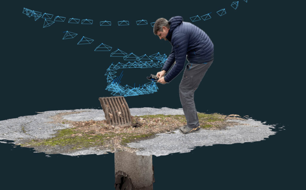
Videogrammetry
Transform video into vivid 3D models with ease. Perfect for documenting complex sites like underground utilities or construction projects.
Our advanced algorithm selects frames that show a change of more than 20%, ensuring that you get the highest quality results without being a video expert. With the 'Automatic' selection feature, there's even no need to manually choose frames; the system will do it for you and simplify your workflow.
With videogrammetry, all you need to do is press "record" and "stop", and 3Dsurvey does the rest, turning your videos into comprehensive 3D models.
Combine your drone imagery and ground-level video frames and use the method that captures every angle, providing a full, detailed 3D model of your site. With the integration of an external RTK antenna, you can achieve geolocated and scaled models with GIS-level accuracy, all without the need for ground control points.
The most valuable information comes from the clients

Mihala Korelc
GEO2 d.o.o. (Slovenia)

Claudiu Toma
Black Light SRL (Romania)

Kamil Tomiak
NaviGate (Poland)
One of the reasons that I am a 3Dsurvey partner, is because their customer service is unbeatable, and because they put out an INCREDIBLE amount of content, to help YOU, the user, make the most out of the software.
They are constantly taking feedback from their customers and putting out helpful webinars, videos, and articles to help you work your job and find solutions to your hang ups.”
Farrah Etcheverry
Etcheverry Land Surveying


Jan Škarja
Šuštar Trans (Slovenia)
3Dsurvey’s support and customer care have surpassed all of our expectations. Marko, Vid and Matija are true professionals, prompt to respond and always happy to help with solutions at hand. Even though we sometimes make their days hard, they make our lives easier – thank you for doing the best job!
Jano Komac
Institut Mediapro


Michael Wenninger
CADdy Geomatics GmbH (Germany)

Pavel Bozdech
3gon Positioning s.r.o. (Czech)
Frequently asked questions
Minimum
Windows 7, 8, 10 / Ubuntu 22.04; 64 bit, Intel i5 or Ryzen 5, 16 GB RAM, nVidia GTX 1050 or better, SSD 128 GB + HDD 500 GB
Recommended
Windows 11 / Ubuntu 22.04 or newer; 64 bit, Intel i7 or Ryzen 7, 32 - 64 GB RAM, NVIDIA RTX 5060 Ti 16 GB, SSD 2 TB (NVMe)
Professional
Windows 11 / Ubuntu 22.04 or newer; 64 bit, Intel i9 or Ryzen 9, 64 - 128 GB RAM, 2x NVIDIA RTX 5060 Ti 16 GB, SSD 4 TB (NVMe)
Disclaimer: Intel Core 13th and 14th Gen K/KF/KS have serious issues with instability and we don't recommend it.
3Dsurvey is designed to be compatible with any drone or any camera. Specifically, DJI Mavic 3E, DJI Matrice 350 / 300 RTK, DJI Phantom 4 RTK, DJI Matrice 4E and many more!
3Dsurvey offers a number of supported file formats: tiff, jpg, png, kmz, obj, ply, e57, las, dxf, pdf, txt, xyz, doc, xml, mp4.
Yes, you can! A free 14-day trial version is available on the free trial page. It has unlimited functionalities! In case 14 days prove too short, please email support@3Dsurvey.si and we'll do our best to assist.
You can send an inquiry about the license type you want to purchase through our store or contact your local 3Dsurvey distributor.
For specific needs, take advantage of our Scan and RTK Videogrammetry solutions
Enhanced data quality and efficient processing, perfect for engineering, environmental science, and urban planning.
Centimeter-level precision for 3D models and maps, ideal for high-detail usage.


")

From 2D images to accurate 3D models
Make the most out of the data you have and create 3D models that will amaze your clients.
3Dsurvey Cloud for easy sharing
Simply share a link and let your client access detailed views and analyses from any device.
Subscribe to our newsletter

