Capture and process your legacy drone images with ease
Use our 3Dsurvey Pilot app and photogrammetry software and process your drone captured images to generate highly accurate, metric and geo-referenced results.
OVERVIEW
Transform your legacy drone into an accurate surveying and mapping tool
Use an ordinary consumer drone and generate highly accurate, metric and geo-referenced results for professional use with our 3Dsurvey Pilot tool.
Accurate mobile app to plan your flight missions
Free addition to 3Dsurvey photogrammetry software
Various flight paths to capture images with GPS data
FEATURES AND BENEFITS
What you can expect from 3Dsurvey Pilot
This tool brings you some unique features and provides even greater efficiency.
Features and benefits for Android
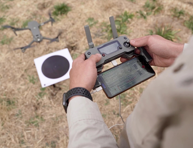
- Automated drone flight & image acquisition
- Telemetry and live camera feed during the mission
- Simple workflow with 3Dsurvey's processing software
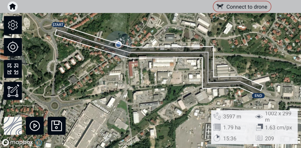
- Flight parameters for each mission - front & side image overlap, camera angle, flying height (AGL), flight speed - can be adjusted based on the requirements of the area and the project
- Advanced settings and options for demanding missions.
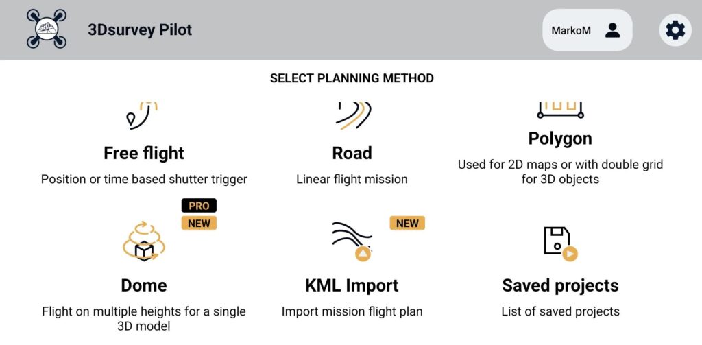
Plan your mission - flight plans for different needs
-
GRID Single Grid or Double Grid for mapping of rectangle areas - the fastest way for planning routes with simple settings.
-
POLYGON Mapping of advanced/irregular shaped areas - additional area shapes and advanced settings.
-
ROAD Developed specifically for simple and effective road, rail & corridor mapping.
-
CIRCLE Circular mission for object mapping - always facing your point of interest for object 3D model reconstruction.
-
URBANSCAN Best mission for 3D model of large urban area
-
FREE FLIGHT Position or time-based shutter trigger. Works also with Mavic mini 2 and Air 2s.
-
DOME Flight on multiple heights for single 3D object.
Please keep in mind: Make sure you have the latest firmware installed and the app is up to date. The app follows the flight plan and does not avoid obstacles automatically. 3Dsurvey accepts no liability for damage, injuries or legalities from the misuse of this app. Use only in safe environments and follow your local drone regulation.
Features and benefits for iOS
- Automated drone flight & image acquisition
- Telemetry and live camera feed during the mission
- Simple workflow with 3Dsurvey's processing software
- Flight parameters for each mission - front & side image overlap, camera angle, flying height (AGL), flight speed - can be adjusted based on the requirements of the area and the project
- Advanced settings and options for demanding missions.
- Post-flight processing & analysis using 3Dsurvey desktop software:
- Capture and recreate natural environment in digital form and survey from the office. Achieve high-resolution outputs with cm-grade accuracy.
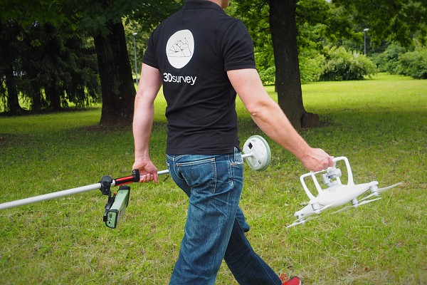
- Use of Ground Control Points (GCPs) for improving the relative and absolute accuracy of the model
Plan your mission - flight plans for different needs
-
GRID Single/Double Grid for mapping of rectangle areas - the fastest way for planning routes with simple settings
-
POLYGON Mapping of advanced/irregular shaped areas - additional area shapes and advanced settings
-
ROAD Developed specifically for simple and effective road, rail & corridor mapping
-
CIRCLE Circular mission for object mapping - always facing your point of interest for object 3D model reconstruction
Please keep in mind: Make sure you have the latest firmware installed and the app is up to date. The app follows the flight plan and does not avoid obstacles automatically. 3Dsurvey accepts no liability for damage, injuries or legalities from the misuse of this app. Use only in safe environments and follow your local drone regulation.
The Pilot App only supports the following drones:
DJI: Phantom 4 Pro V2, Phantom 4 Pro, Phantom 4, Phantom 3 Professional, Phantom 3 Advanced, Mavic Air, Mavic Pro, Mavic 2 Pro, Inspire 1 (Pro), Inspire 2, Spark
Frequently asked questions
3Dsurvey Pilot supports various older DJI drones, including:
- Phantom Series: Phantom 4 Pro V2, Phantom 4 Pro, Phantom 4, Phantom 3 Professional, Phantom 3 Advanced
- Mavic Series: Mavic Air, Mavic Pro, Mavic 2 Pro
- Inspire Series: Inspire 1 (Pro), Inspire 2
- Spark
3Dsurvey Pilot offers several mission planning options to suit different surveying needs:
- GRID: For mapping rectangular areas quickly with simple settings.
- POLYGON: For mapping complex, irregular-shaped areas with advanced settings.
- ROAD: Specifically designed for road, rail, and corridor mapping.
- CIRCLE: For circular missions, always focusing on a point of interest, ideal for object 3D model reconstruction.
After the flight, the captured images can be processed using the 3Dsurvey desktop software to generate high-resolution, accurate outputs such as:
- Dense point clouds
- 3D meshes
- Topography maps
- Elevation models (DSM, DTM, DEM)
- Orthophotos
- CAD files
- Contour lines
- Profiles and cross sections
The software supports various data sources, including LiDAR, Sonar, SLAM, and terrestrial scanners, and is optimized for fast processing with both CPU and GPU support.
3Dsurvey Pilot will not be updated to support newer drones due to DJI's evolving SDKs, software policies, and the introduction of DJI Fly.
3Dsurvey Pilot only supports legacy DJI drones, however, 3Dsurvey software is compatible with any drone, any camera, including older drone models. The most commonly used drones for photogrammetry currently include DJI Mavic 3E, Matrice 4E and Matrice 300 RTK and Matrice 350 RTK.
Dive in and level up your skills!
Free Trial - Fully functional, no limitations - for 14 days
Check out all the features and additional modules of 3Dsurvey software and see if it fits your needs, then choose the appropriate licence.
-
 All-in-One solution
 -
Onboarding training included
-
Supports 18 languages

Subscribe to our newsletter

