Summary
Wondering what is an orthophoto? An orthophoto is an aerial or satellite image corrected to remove distortions, making it accurate enough for mapping and measurement. It is widely used in surveying, GIS, construction, agriculture, and more.
First developed in 1937, orthophotos have become essential for professionals needing precise, up-to-date visuals. With tools like 3Dsurvey, users can create their own high-resolution orthophotos using drone images—especially useful when public satellite data lacks detail.
From surveyors to farmers and emergency teams, orthophotos help visualize, plan, and communicate with accuracy and confidence.
What is an orthophoto?
An orthophoto is a geometrically corrected aerial or satellite photograph that has been adjusted to remove distortions caused by camera tilt, terrain relief, and other factors. The result is an image that can be used as a map, with a uniform scale and no distortions, allowing accurate measurements to be taken. In other words: 1 meter is 1 meter anywhere on the image; the center, the side and the corner
Orthophotos are commonly used in geographic information systems (GIS) and other applications that require accurate mapping and measurement. They can be used to create detailed maps of areas, to measure distances and areas accurately, and to identify features such as buildings, roads, and vegetation.
The process of creating an orthophoto involves combining:
- aerial or satellite photographs and
- data on the location and elevation of the camera and the terrain.
This information is used to remove distortions caused by the camera angle and the shape of the terrain, resulting in an image that accurately represents the ground surface.
When was the first orthophoto created?
The first attempts to create a map out of aerial photographs date back to Napoleone times. In 1858 Gaspard-Félix Tournachon (Nadar) was the first person to take aerial photos from a hot air balloon. Nadar’s photograph was not a map or a scientific study, but rather a work of art.
The first orthophoto was then supposedly made in 1937 by a team of photogrammetrists led by the American engineer and inventor, Sherman Fairchild. The team used a special airplane camera and a technique known as “orthophotography,” which involved combining multiple aerial photographs to produce a map-like image of the ground surface.
The early uses of orthophoto included cartography, land surveying, and urban planning. The ability to produce maps with accurate measurements and true-to-scale representations of the Earth’s surface was a major breakthrough, and orthophotos quickly became an essential tool for surveyors, engineers, and planners.
During World War II, orthophotos were used extensively by the military to create detailed maps of enemy territory and to identify strategic targets.
In the decades that followed, the uses of orthophoto expanded to civil organizations including forestry management, environmental monitoring, and natural resource exploration. Orthophotos were used to map and monitor forested areas, to identify areas of erosion and environmental damage, and to explore for mineral resources.
Who uses orthophoto today?
Today, orthophotos are used for a wide range of applications, including:
- surveying,
- construction,
- land-use planning,
- transportation planning,
- coastal management,
- hazard mapping, and
- emergency response.
Orthophotos are also an important tool for virtual reality, video game development, and other forms of digital media.
In fact, today we encounter orthophotos on our daily bases. They are so common that we even take them for granted. That is, until we find a patch of land that interests us and is only covered with a low resolution satellite image patch. That is where and when you can take matters into your own hands, grab your drone, fly over the area, take enough pictures, process them in 3Dsurvey and make yourself the best orthophoto map you could ask for.
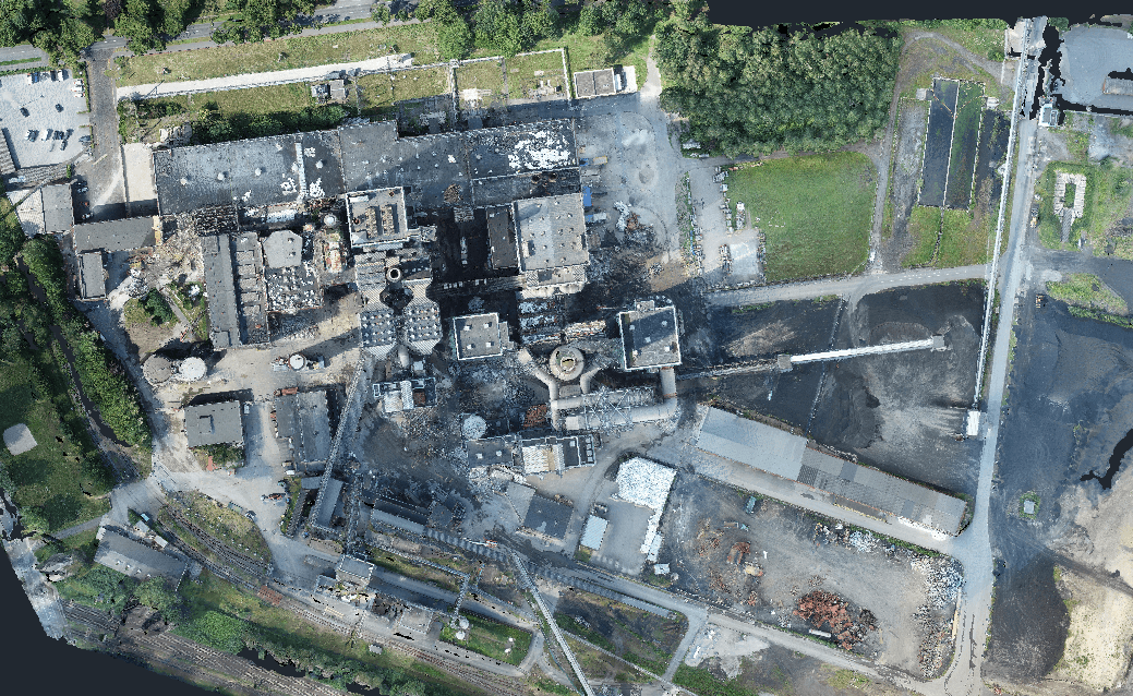
True or Traditional orthophoto?
Have you ever wondered what is the difference between true and traditional orthophoto and when to use which? Luckily we’ve got you covered.
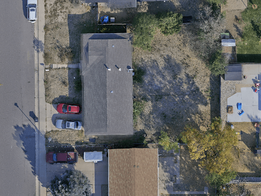
True orthophoto
- Built from a Full 3D mesh – Based on high fidelity representation of the real world with all the above-ground features, like buildings and trees in their true place.
- Removes tilt and occlusion – every point, even building façades, is projected vertically, producing accurate geometry.
- Slower and more compute-intensive, requiring high overlap imagery and detailed 3D models.
Use it for: urban planning, construction mapping, cadastral work, change detection, feature extraction—any project where vertical accuracy and building representation matter.
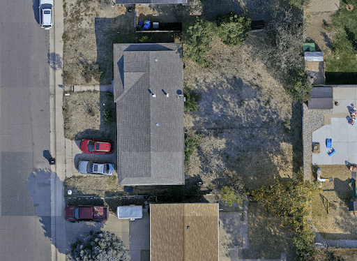
Traditional orthophoto
- Built from a Digital Terrain Model (DTM) – models only the ground surface, ignoring buildings and trees.
- Buildings and tall structures appear tilted or displaced – this is fine in rural or flat areas (e.g., agriculture, forestry) .
- Faster and less resource-intensive to produce – ideal for projects needing quick turnaround or focusing on terrain.
Use it for: agriculture, environmental monitoring, mining surveys—where above-ground accuracy isn’t critical.
Want to know more about true vs traditional orthophoto? Read our blog post.
Orthophoto in 3Dsurvey software
Whether you’re working with true orthophotos for urban precision or traditional ones for terrain-focused mapping, the ability to create your own high-resolution, distortion-free maps puts powerful insights at your fingertips.
With 3Dsurvey, producing orthophotos is fast, accurate, and fully under your control. Our all-in-one photogrammetry software is trusted by professionals worldwide and optimized for 2025 workflows—from drone image processing to full-scale map generation.
Curious how 3Dsurvey stacks up against the rest? Read:
Ready to try it yourself? Check our pricing and start your free trial here.

