Best-in-Class Point Cloud
The technology of 3Dsurvey software prides itself on what matters the most – unparalleled precision resulting in detailed, dense and survey-grade accurate point clouds with as minimal noise levels as possible. You can create point clouds with data from drones, cameras, handheld devices, LIDAR, and GNSS!
We are here to assist you with selecting the right hardware for mapping so you will get the best results to suit your needs.
Orthophoto
Whether you need traditional, true, or custom plane orthophoto – we have you covered! Orthophotos are geometrically corrected aerial or satellite images which have a variety of applications. They are commonly used for mapping and GIS, urban planning and development, environmental monitoring and management, engineering and industrial projects, disaster management and more.
Embrace the diversity and accuracy of our orthophoto generation capabilities for your next project.
Check additional information below and feel free to contact us with any additional questions.


For areas without buildings. With faster processing than true orthophotos and sharpest images, the traditional orthophotos are ideal for volume calculations and stockpile assessments.
*Before initiating, please make sure your point cloud is appropriately classified and employ a Digital Terrain Model for accurate results.
For densely built urban areas. The true orthophotos ensure even more precision and even greater accuracy and visual fidelity and minimize distortions caused by building facades and other vertical structures.
*Their quality depends on the Textured Full 3D Mesh's accuracy. To minimize edge artifacts on roofs and similar structures, mapping with oblique images is recommended for optimal True Orthophoto results.
For detailed façade mapping. Offering a specialized view of building facades, the custom facade orthophotos are invaluable in architecture, urban planning and infrastructure management. They are ideal for situations where your focus shifts to detailed facade mapping for subsequent vectorization. Adjust the calculations to your needs and create a side orthophoto or one for a specific aspect like roof mapping.
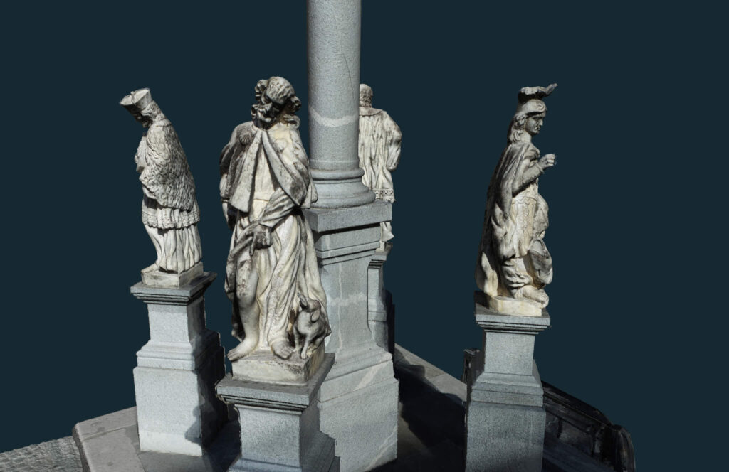
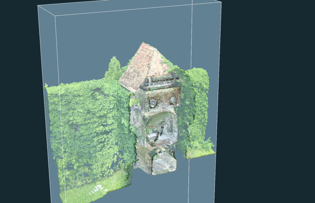
Mesh
Meshes play a crucial role in surveying by providing a geometrically accurate representation of terrain and objects, enabling surveyors to analyze, visualize, and model the surveyed environment with precision. Meshes are commonly generated from point cloud data. After capturing the point cloud data, the software processes it to create a mesh representation. This process involves connecting neighboring points to form triangles or other polygons, resulting in a mesh that accurately reflects the surface geometry.
Formed from equally sized triangles arranged in a grid, it derives from photogrammetry or LIDAR point clouds. When generating a Regular Grid Mesh, you have the control to define the grid cell size (e.g., 0.5 meters), set a smoothing factor, and choose a hole-filling mode. This flexibility allows for the creation of multiple mesh models with different settings from the same point cloud. For instance, one model can be optimized for volume calculations, while another can be tailored for contour line calculations (by increasing the smoothing cell size factor to 3 cells and adjusting the grid cell size to 0.5m or 1.0m for larger data sets).
Full 3D Mesh Designed for comprehensive 3D modelling, the Full 3D Mesh option is ideal for detailed surface representation.
Triangulated Mesh from CAD Data (Delaunay Triangulation) This type of mesh is particularly useful for projects involving CAD data, providing precise triangulation to represent complex surfaces.
A textured mesh goes a step further from Triangulated mesh by adding a layer of texture onto the grid mesh. This texture is a 2D image that is mapped onto the surface of the 3D model, providing additional visual details like color, patterns, and realistic surface appearances. The texture makes the model appear more lifelike or true to its real-world counterpart.
Classification
Experience the ease of semi-automatic point cloud classification with our advanced, user-friendly engine. Our cutting-edge technology with sophisticated customization tools for assigning new classes allows for precise and efficient object recognition, feature extraction and data filtering, and faster workflow.


Our intuitive one-click solution efficiently classifies your point cloud into 'Ground' and other relevant categories. Use your energy and time wisely with this streamlined process that helps you with precise and accurate volume calculation or contour line creation, where only ground or terrain points are required.
By focusing solely on ground/terrain points, you can achieve the smoothest and most detailed terrain models, unobscured by buildings or vegetation. This precision is invaluable in projects demanding high-detail terrain mapping.
For any application where automatic classifications are not the best solution. You can always manually assign selected points to new classes. With our feature "Select by Color" you can still use some help to segregate specific elements like building roofs or vegetation into distinct classes, or for removing unwanted point cloud noise and colors.
Bounding box
The bounding box is a valuable tool for defining spatial extents, facilitating spatial analysis, and aiding in data visualization tasks. It provides a simple yet effective means of representing the geometric properties of features in surveying datasets.
You can set spatial limits for a survey or 3D modelling project to mark the area you need to work on.
Unnecessary data only hinders your work and can create chaos and slow down your working process. The bounding box tool helps in organizing and managing large datasets by filtering out unnecessary data outside the defined area.
The most valuable information comes from the clients

Mihala Korelc
GEO2 d.o.o. (Slovenia)

Claudiu Toma
Black Light SRL (Romania)

Kamil Tomiak
NaviGate (Poland)
One of the reasons that I am a 3Dsurvey partner, is because their customer service is unbeatable, and because they put out an INCREDIBLE amount of content, to help YOU, the user, make the most out of the software.
They are constantly taking feedback from their customers and putting out helpful webinars, videos, and articles to help you work your job and find solutions to your hang ups.”
Farrah Etcheverry
Etcheverry Land Surveying


Jan Škarja
Šuštar Trans (Slovenia)
3Dsurvey’s support and customer care have surpassed all of our expectations. Marko, Vid and Matija are true professionals, prompt to respond and always happy to help with solutions at hand. Even though we sometimes make their days hard, they make our lives easier – thank you for doing the best job!
Jano Komac
Institut Mediapro


Michael Wenninger
CADdy Geomatics GmbH (Germany)

Pavel Bozdech
3gon Positioning s.r.o. (Czech)
Frequently asked questions
Minimum
Windows 7, 8, 10 / Ubuntu 22.04; 64 bit, Intel i5 or Ryzen 5, 16 GB RAM, nVidia GTX 1050 or better, SSD 128 GB + HDD 500 GB
Recommended
Windows 11 / Ubuntu 22.04 or newer; 64 bit, Intel i7 or Ryzen 7, 32 - 64 GB RAM, NVIDIA RTX 5060 Ti 16 GB, SSD 2 TB (NVMe)
Professional
Windows 11 / Ubuntu 22.04 or newer; 64 bit, Intel i9 or Ryzen 9, 64 - 128 GB RAM, 2x NVIDIA RTX 5060 Ti 16 GB, SSD 4 TB (NVMe)
Disclaimer: Intel Core 13th and 14th Gen K/KF/KS have serious issues with instability and we don't recommend it.
3Dsurvey is designed to be compatible with any drone or any camera. Specifically, DJI Mavic 3E, DJI Matrice 350 / 300 RTK, DJI Phantom 4 RTK, DJI Matrice 4E and many more!
3Dsurvey offers a number of supported file formats: tiff, jpg, png, kmz, obj, ply, e57, las, dxf, pdf, txt, xyz, doc, xml, mp4.
Yes, you can! A free 14-day trial version is available on the free trial page. It has unlimited functionalities! In case 14 days prove too short, please email support@3Dsurvey.si and we'll do our best to assist.
You can send an inquiry about the license type you want to purchase through our store or contact your local 3Dsurvey distributor.
For specific needs, take advantage of our Scan and RTK Videogrammetry solutions
Enhanced data quality and efficient processing, perfect for engineering, environmental science, and urban planning.
Centimeter-level precision for 3D models and maps, ideal for high-detail usage.


")

Only use the data you need
Different tools enable you to extract and create the information you need, from volume calculation to drawing profile lines.
3Dsurvey Cloud for easy sharing
Simply share a link and let your client access detailed views and analyses from any device.
Subscribe to our newsletter

