CAD drawing with image support
Sometimes it’s really difficult to extract some specific detail from the point cloud or mesh accurately. Building corners, roof ridges or road curbs are just some of those examples. With the new 2.16 version of the software, you are able to select the exact position of your CAD vertex on the images and triangulate its new and most precise position.
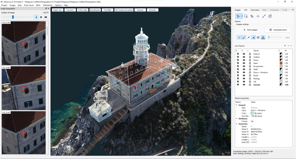
Using this function, no additional terrestrial measurements with the help of a total station are needed! Create a 100% precise model with 3Dsurvey photogrammetry and speed up your work process!
Check out this VIDEO to see it in action.
This feature revolutionizes the way you draw the most detailed plans. No more guessing whether you clicked precisely when pinning down the circle centre or a hairline detail.
No more frustration with zooming in a low-detailed 3D model, even if your point cloud is sparse or your mesh is low on triangles, all your images are there for you in their full resolution to give you insight into the smallest detail.
So even if you haven’t found photogrammetry useful so far, you may need to re-think it. The option to check every spot and corner of a point cloud on an image that captured the selected point opens up the whole spectre of new potential use cases.
At the same time, we believe an existing user will appreciate this new feature, for it will most definitely save you time and improve your accuracy
No need for hand measurements anymore when dealing with facade details. All you need is a good point cloud and you can measure all elements from your office. Further on you can even export all the details and measurements to your prefered CAD application in selected layers if needed
Car accidents are now mapped even more precisely as you can measure with millimetre accuracy.
Additional targets support
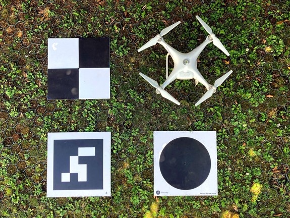
The black dot on a white plate is a traditional 3Dsurvey target which works perfectly in most conditions and offers a semi-automatic workflow for accurate orientation with minimum user input.In the 2.16 version we now support the following target types:
A black circle on a white plate. The already well-known 3Dsurvey target is now improved with an additional centering algorithm.
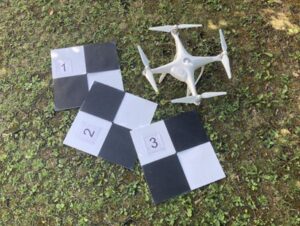
A square field with quarters of white and black squares placed diagonally. A simple target with a superb level of detection.
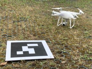
The tags act like barcodes. Each one has a unique, pre-defined ID. This enables you to use their main advantage – autodetection. Ideal for lower altitude flights (up to 40 m for standard 30 x 30 cm size) or smaller sites mapped with handheld devices (digital camera, phone, etc.). Detection and orientation are fully automated, no manual clicking is needed. So far the software supports the 16h5 family.
AprilTag support opens up a whole array of new possibilities. AprilTags are the most practical GCP targets to use indoors, for small projects and videogrammetry. Once you set them up, you will never have to worry about whether your object is correctly scaled or not.

Apply transformation to the entire project
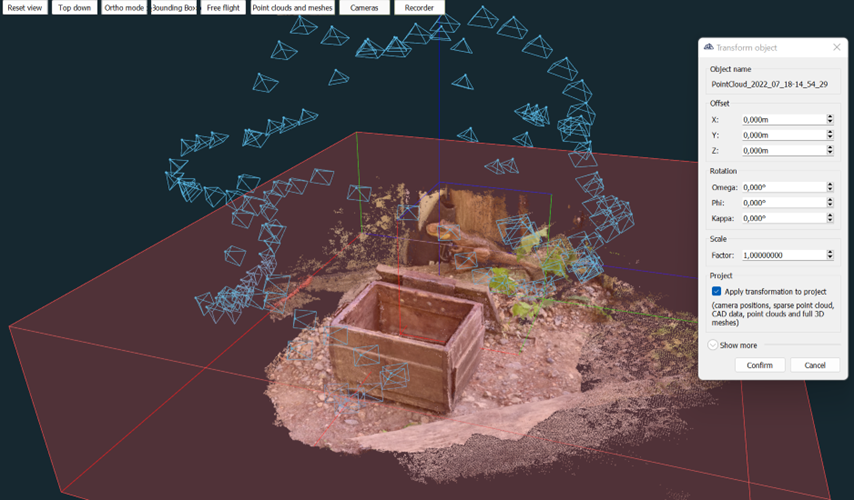
You now have the ability to orientate any element of your project and with this option checked. All* project elements will automatically adapt to the same transformation.
*This option does not affect the contours, profiles, volumes, regular mesh and circles.
It may sound trivial, but orienting two-point clouds is now super easy: no need to remember or copy the settings of the first orientation and then repeat it.
Now you can orientate the mesh and all elements of the project will follow. All CAD layers adapt to their new locations, you can calculate the texture again and so on.
This feature is especially useful for videogrammetry users. When you want to create a quick 3D model with nothing but your smartphone, transformation is practically unavoidable. Or simply any user working without telemetry (texture photographer, enthusiast, a user on a budget…).
If you don’t have a telemetry system, this new feature is perfect for you!
OBJECT TRANSFORMATION TOOL
Now even better! No more pain when importing models which are not on the right coordinates or not geolocated! You can now combine them with calculated realistic models in 3Dsurvey 2.16 – easily move, rotate and scale the model to the right size and coordinates with our all new Object transformation tool! Works on imported or calculated OBJ models, point clouds or any other data types! Feature can be used in following situations:
- Placing a design model in real space (for architects and designers)
- Placement of the captured 3D model on the right coordinates, scale and orientation in space:
- Two coordinate systems – no need to calculate again
CAD data export – Select a list of layers
The CAD module has been a part of 3Dsurvey since the beginning. It’s one of our most appreciated features by our users. Based on your feedback we now added an option to export only the selected layers.
When you want to save your CAD data, an additional window opens up after you choose the file’s location and type. In this new window you select the layers you want to export. By default, only visible layers are selected, but of course, you can make your own selection.
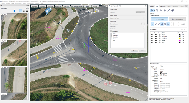
This is especially convenient when you’re working with several layers and you want to, for example, export them one by one in separate files. Some users have 20 or more layers in their projects so this update is essential to them.
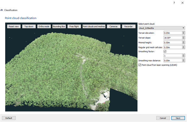
Classification improvements for LIDAR datasets
Lidar technology is getting more and more popular among photogrammetry users. 3Dsurvey already supports working with Lidar data with functions like colourizing for example. With this update, we have improved the classification for point clouds from laser scanning.
If you’re classifying a Lidar dataset, make sure you check this new option we made available.
With the help of this function, we detect the lowest points of your point cloud more accurately. Even when you’re working with the images above the densest forest.
