Key takeaways
3Dsurvey’s Scan module lets you import and work with high‑precision scan data (e.g., FARO Orbis) in common formats like .e57 and .laz.
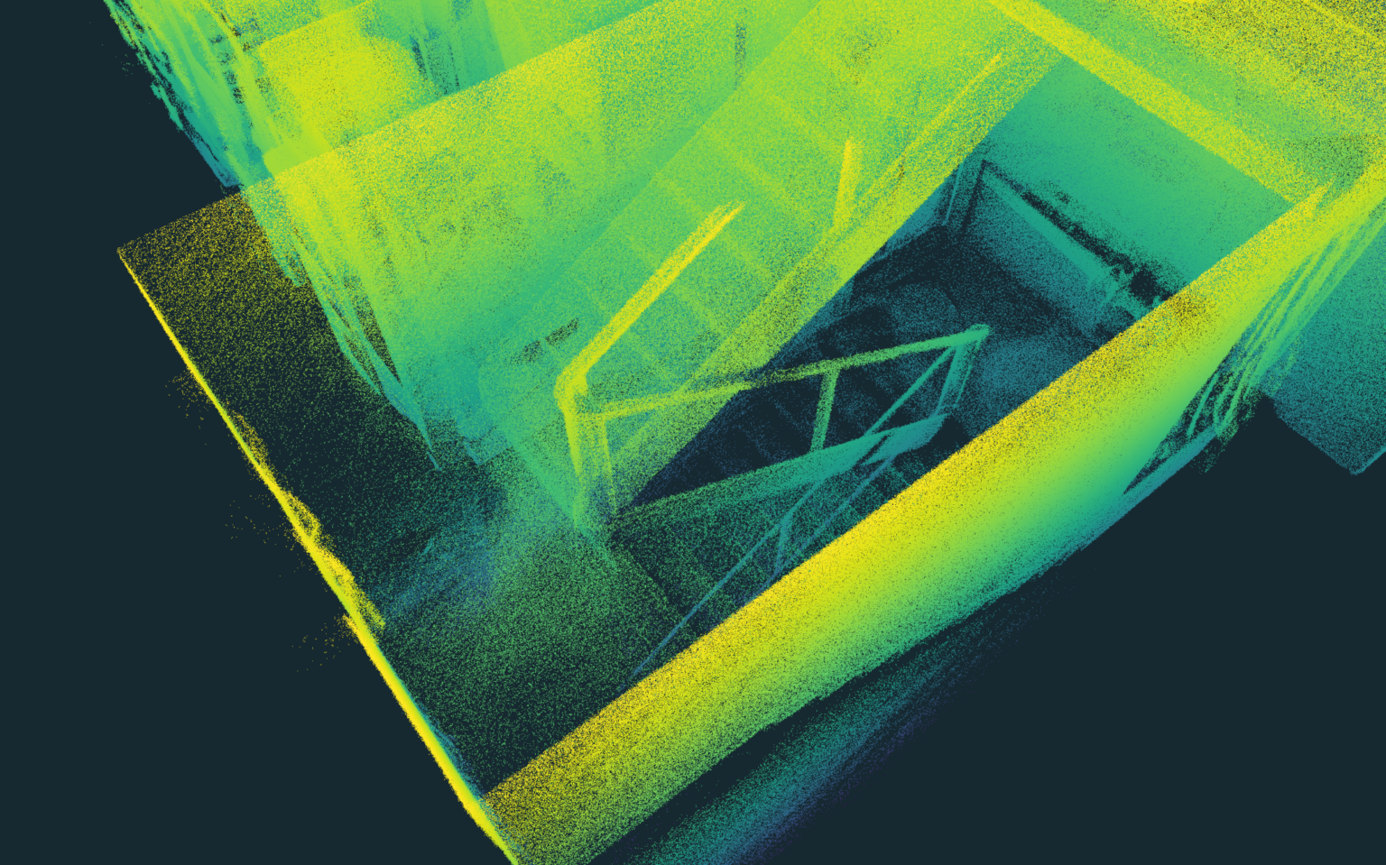
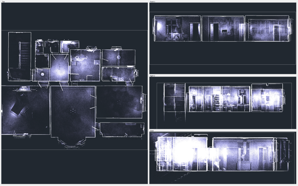
With X‑ray views, you can visualize and draw structural floor plans and cross-sections directly on the point cloud.
CAD integration inside 3Dsurvey enables quick drawing, snapping to layers, and editing even for users with minimal 3D software experience.
The workflow is very efficient: scanning and drawing took only 3 hours compared to about 10 hours with traditional survey methods.
The end deliverables (like 2D floor plans) matched the quality of conventional methods, while the process was faster and more accessible.
Introduction
The modern 3D data acquisition landscape keeps evolving with regards to new hardware and software available on the market. Diverse methods like high-precision ground scanning and videogrammetry via mobile phones offer versatile solutions for 3D data collection. A prominent example is the integration of handheld 3D scanners for indoor environments with drone-based surveys of outdoor surroundings. 3Dsurvey software, augmented with its new Scan and RTK Videogrammetry modules, demonstrates powerful capabilities in combining multiple data sources, offering efficient workflows and high-quality outputs.
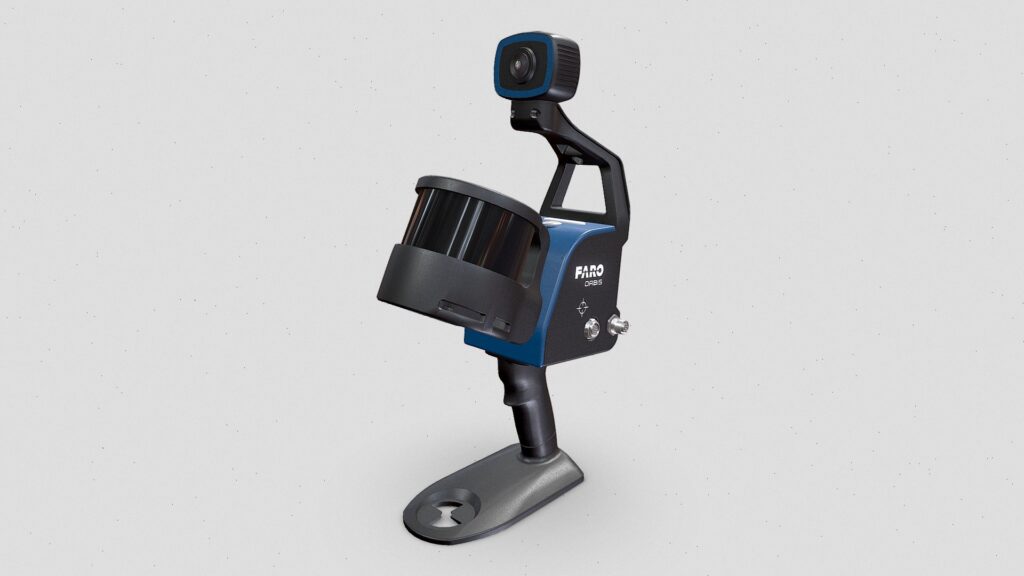
In this use case, we explore a project undertaken by Pavel Bozdech of 3gon Positioning s.r.o, a 3Dsurvey Gold Level Partner in the Czech Republic. The project involved creating detailed floor maps and cross-sections of an apartment suite in an old building in Prague. The data was captured using the FARO Orbis handheld 3D laser scanner and processed using 3Dsurvey software’s Scan module.
Project Overview
The primary goal of this project was to document the interior space of an apartment suite for construction authorities and designers. 3Dsurvey software facilitated the creation of X-ray views, which were used to draw detailed floor maps directly within the software before exporting to CAD software for further annotations. This approach was favored for its simplicity and speed, making it accessible even to those with minimal training in 3D technology.
Site and Conditions
The project site was located in the heart of Prague, within an old building slated for renovation. The apartment suite was recently vacated, providing a clean environment for scanning. However, careful consideration was given to moving potential obstructions, such as curtains, to ensure clear visibility in the X-ray views.
Technology and Methodology
The project utilized the FARO Orbis handheld mobile 3D laser scanner, which offers a 5mm accuracy without the need for extensive calibration or setup. The simplicity of the scanner allowed the operator to walk around the suite, capturing data with ease.
To ensure accuracy, control points were measured directly by the scanner, which is crucial in maintaining a robust and precise trajectory in SLAM (Simultaneous Localization and Mapping) technology. One of the key advantages of using 3Dsurvey software with the FARO Orbis scanner is the universality of the software. Just open the data from 3D laser scanner in various formats such as *.e57 or *.laz.


Problem-Solving Approaches
One of the main challenges encountered during the project was the data processing phase. While field data collection was straightforward, transforming the point cloud data into deliverables that met client expectations was more complex. 3Dsurvey software proved invaluable in this regard, enabling even untrained personnel to efficiently produce the necessary drawings.
While alternative methods such as BIM modeling or classical surveying could have been used, they would have required more specialized knowledge or been significantly slower. The decision to use 3Dsurvey was based on its simplicity, speed, and the ability to visualize and draw directly on the point cloud.
Data Processing and Analysis
3Dsurvey software’s Scan module provided essential tools for processing the captured data. Large point clouds were easily handled, and X-ray views were generated quickly, allowing for seamless CAD data verification. The ability to work with CAD drawings in layers directly within the software further streamlined the workflow, making it accessible to non-specialists.
Outcomes and Results
The use of 3Dsurvey software significantly enhanced project efficiency. The entire process of scanning and drawing took only 3 hours, compared to the 10 hours that would have been required using classical survey methods. This efficiency is particularly beneficial for handling multiple projects simultaneously, as one operator can scan several sites in a single day.
The final deliverable, a 2D floor plan, was equivalent in quality to what would have been produced by more traditional methods. However, the speed and flexibility offered by 3Dsurvey provided a distinct competitive advantage.
Lessons Learned and Future Applications
Looking ahead, the versatility of 3Dsurvey software positions it as a valuable tool for a wide range of applications, from mapping and volume calculations to detailed building inspections and CAD drawing. The integration of scan data and photogrammetry in larger projects presents exciting opportunities for future innovation.
In summary, 3Dsurvey software, with its powerful Scan module, offers an efficient, user-friendly solution for integrating diverse 3D data sources, solving complex problems, and delivering high-quality outputs in a fraction of the time required by traditional methods.

