High-Accuracy Aerial Survey Under Flight Restrictions
Key takeaways
High-accuracy aerial surveys are achievable even under strict flight restrictions with the right flight planning and processing workflow.
Multi-angle (nadir + oblique) flight strategies effectively compensate for limited flight altitude and improve data completeness around buildings and vertical structures.
Repeatable, consistent results are possible across multiple survey cycles, even on rapidly changing construction sites.
An integrated photogrammetry and CAD workflow streamlines processing, reduces software switching, and supports complex deliverables.
Reliable turnaround times can be maintained despite large datasets and regulatory constraints.
Introduction
Large-scale commercial developments demand accurate, up-to-date survey data, often on tight deadlines and under challenging conditions. In the greater Phoenix area, where development is expanding rapidly, one surveying firm, Bugzeye Drone Mapping and Photography, has built a repeatable aerial workflow to keep pace with constant change.
This case study highlights Bugzeye’s ongoing aerial survey project covering a 50-acre portion of a major strip mall development. With strict flight restrictions, 2 week delivery timelines, and the need for consistent re-surveys every few months, the project demonstrates how a well-designed drone workflow and integrated processing software can deliver reliable results at scale.
Project Description
The project focuses on the southern 50 acres of a large strip mall development located in the greater Phoenix area, Arizona, where development began in 2022. The images in this case study show an aerial survey captured and processed in 2023.
What was farmland only a few years ago is now an active commercial corridor with new buildings, infrastructure and site improvements occurring regularly. The survey data is handed over to be used by an engineering firm. Whenever ownership changes or new structures are added the site must be re-surveyed to maintain accurate, current data.
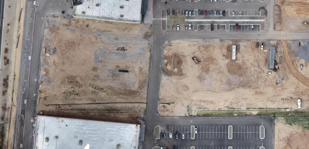
Orthophoto crop of the southern portion of the site (2023 survey)
Fieldwork
Aerial data collection is performed using DJI Matrice 300 and Matrice 350 drones equipped with the P1 camera. Due to the site’s proximity to active military operations, flight height is restricted to a maximum of 200 feet.
The 50-acre southern portion of the site typically takes around two hours to fly, while the full development can take up to three hours. Ground control points (GCPs) are placed using survey targets to ensure positional accuracy.
Survey Approach
To maximize data completeness and quality, Jerry Hammond uses a five-flight strategy for every visit:
One nadir (90°) flight for orthoimagery
Four oblique flights (45°) from the north, east, south, and west
This multi-angle approach ensures comprehensive coverage of vertical features such as building façades, site edges, and vegetation, particularly important in desert environments with dense cacti and structures that can obscure ground detail.
Flying slower and collecting imagery from multiple perspectives has also significantly improved data quality with less motion blur. Now with version 4.0, the team has noticeably crisper building edges and more reliable surface models. These refinements are especially important given the repeated nature of the surveys, where consistency between datasets matters as much as accuracy.
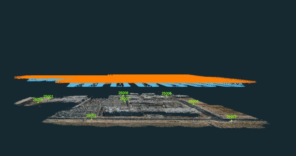
Side view showing the aerial camera perspective and GCPs
Tools Used
Drones: DJI Matrice 300 & Matrice 350
Camera: DJI P1
Processing Software: 3Dsurvey
Jerry highlighted the value of using one integrated software platform that combines photogrammetry, point cloud processing, and CAD-related tools. Compared to other modular solutions that require jumping between applications, this streamlined approach reduces complexity, an important factor when managing projects far larger than average client sites.
In fact, while this case study focuses on a 50-acre area, Jerry’s firm regularly processes projects exceeding 3,700 acres, making software efficiency critical at scale.
Processing
Despite flight restrictions and large data volumes, the team consistently meets their firm’s standard 15-day turnaround, covering both aerial and ground survey components.
Processing time typically includes:
2–3 hours of operator setup and flying
36–50 hours of computer processing, often running continuously over multiple days
Recent software updates, applied during later survey phases, have improved surface modeling and building definition by reducing “bubbling,” producing cleaner and more usable outputs.
Top-down view showing the aerial camera perspective, flight route, and 8x ground control points (GCPs) marked in green.
Results & Deliverables
Standard deliverables for each survey cycle include:
Orthophoto
CAD point grid
Digital Terrain Model (DTM)
Point cloud (LAS / LAZ) compatible with Carlson
The improved five-flight workflow and improved mesh and orthophoto quality have led to:
More accurate DTMs
Crisp, well-defined building outlines
Reliable point clouds for engineering and CAD use
Repeatable results across multiple survey cycles
Despite processing demands, the team consistently meets their firm’s 15-day turnaround standard, covering both aerial and ground survey components.
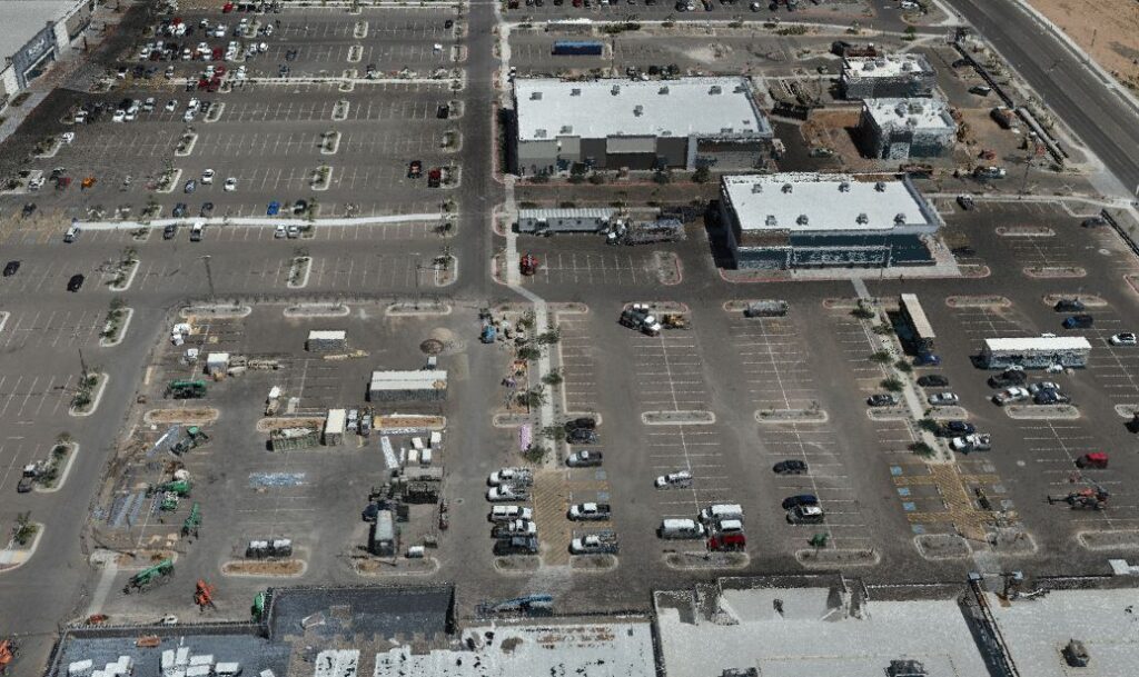
3D side view showing site details (2023 survey)
Conclusion
This Phoenix aerial survey project shows how a repeatable drone workflow can deliver reliable, high-quality results, even under strict flight restrictions and tight deadlines. By combining a five-flight capture strategy with integrated processing tools, Bugzeye’s team consistently produces accurate orthoimagery, DTMs, CAD data, and point clouds for a rapidly evolving commercial site.
As development in the greater Phoenix area continues to accelerate, the ability to resurvey efficiently and maintain data consistency has become critical. This case study highlights how thoughtful flight planning, scalable software, and responsive support enable surveyors to turn complex, ongoing projects into dependable, repeatable operations. It helps to have a reliable software as well, which 3Dsurvey has proven to be. You can start your 14-day free trial and test it on your projects to see for yourself.
Note: Images are from a 2023 survey phase. Screenshots shown were processed prior to later software updates that further improved edge definition and surface clarity.