Key takeaways
- Repeatable RTK drone surveys and orthophoto outputs with 3Dsurvey enable accurate inventory digitization and visualization at Blue Phoenix’s 90,000 m² Krefeld recycling site.
- Weekly orthophotos and biannual volume calculations replace manual laser-based approximations.
- Data capture drops from 1 full day → 15–20 min, with deviations reduced by 10,000–15,000 tons.
- Accurate digital inventory supports sales, logistics, production planning, and audits.
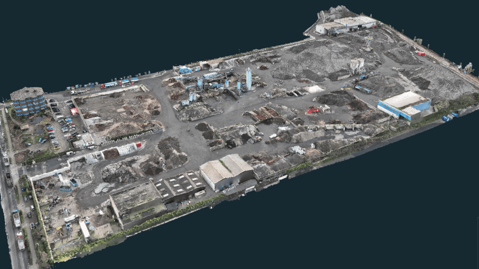
Location and Site Overview
Blue Phoenix Deutschland GmbH operates a 90,000 m² industrial recycling site in Krefeld, Germany, where it processes Incinerator Bottom Ash (IBA) into Incinerator Bottom Ash Aggregate (IBAA). Annually, the Krefeld site handles approximately 150,000–200,000 tons of material. The facility transforms the byproduct of burned household and industrial waste into a certified substitute building material, supplying construction projects under contract.
Turning Waste into Resources at Industrial Scale
The processing workflow is complex and high-volume. Incoming IBA is first screened, and impurities or unburned material are removed. Ferrous and non-ferrous metals are recovered for recycling, while the remaining mineral fraction is refined into IBAA. On a site of this size, where stockpiles are constantly changing, inventory accuracy is not merely a “nice-to-have.” It directly impacts:
- Sales planning
- Production scheduling
- Logistics coordination
- Contract fulfillment
- Financial audits
And until recently, stockpile measurement relied largely on approximation.
A Laser Distance Meter and Approximations
Before adopting digital surveying, inventory measurement was a manual and time-consuming process. Two employees would measure piles using a laser distance meter, estimate their height and length, and approximate volumes by simplifying piles into geometric shapes like pyramids or rectangles. Density estimates were applied to calculate tonnage. The process typically required a full working day for measurement, with additional time needed for calculations. Although calculations were fast, this approach was often unreliable.
Over six months, discrepancies could reach 10,000–15,000 tons due to weighing tolerances and water loss, as well as chemical reactions within the stockpiles. This creates significant uncertainty for a site handling up to 200,000 tons annually, leading to planning risks.
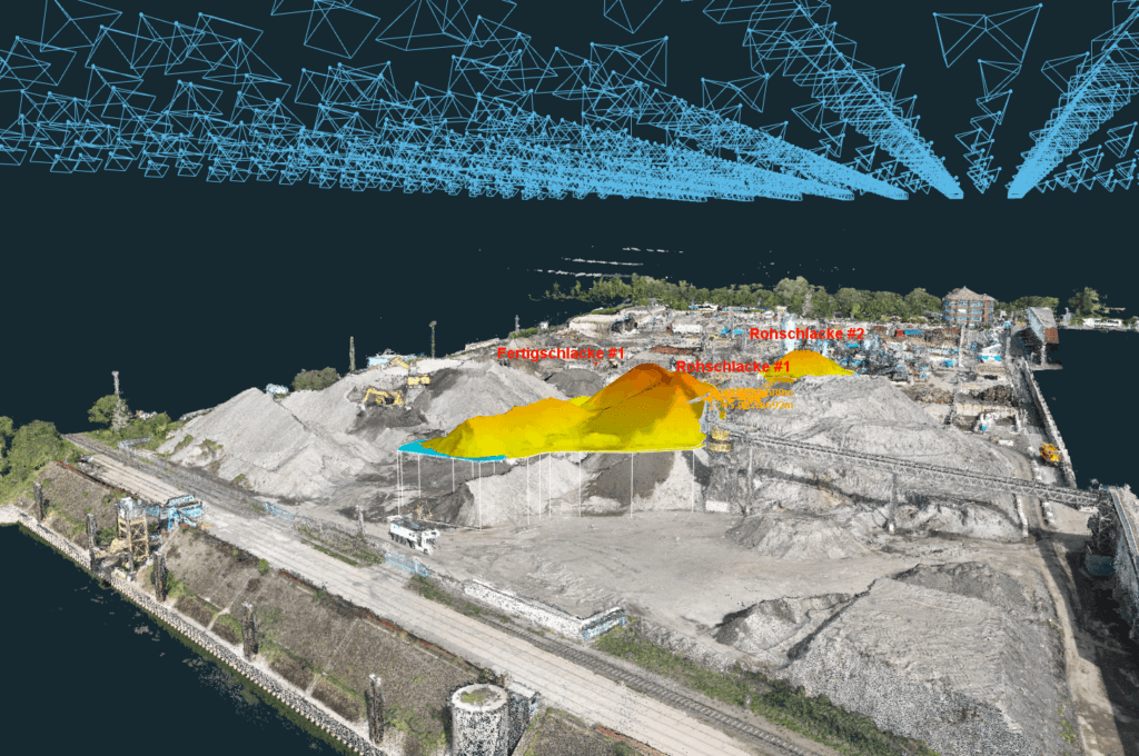
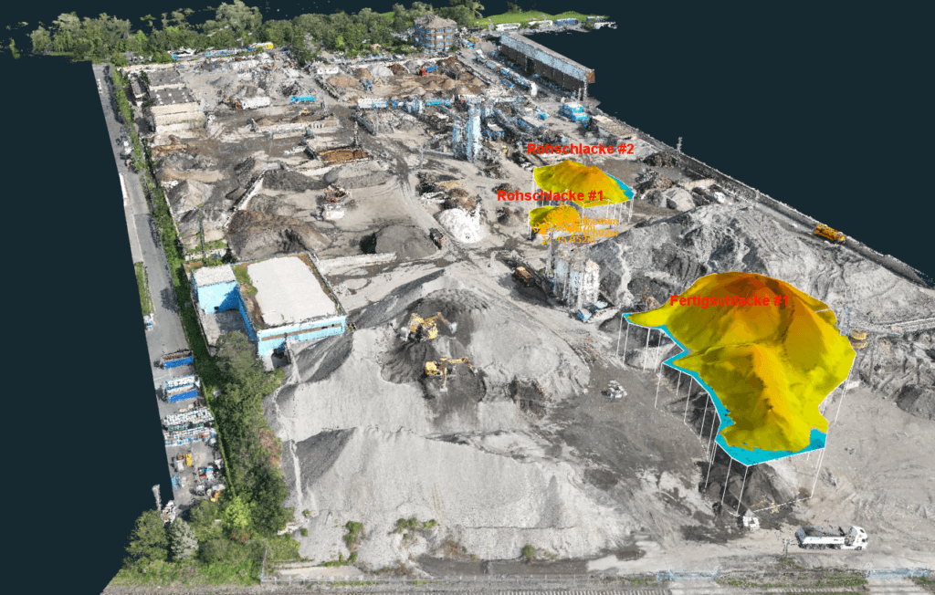
RTK Drone Surveying with Weekly Orthophotos
In December 2024, the Krefeld site introduced a new workflow using a DJI Mavic 3 Enterprise drone paired with 3Dsurvey.
Data Capture Workflow
- Fully automated repeatable flight pattern
- Flight time: 15–20 minutes
- RTK-enabled drone positioning (no ground control points currently used)
- Weekly flights for orthophotos
- Biannual (moving toward monthly) detailed stockpile volume calculations
Processing time:
- 1–2 hours initial processing
- ~16 hours total automated processing time
The key difference is that the investment is in computation rather than manpower.
Why Accuracy Matters
Accurate inventory data drives critical decisions at Blue Phoenix. Management can determine how much material the sales team can commit to, how much space remains on site, how much intake can be accepted, and whether contractual delivery volumes can be guaranteed. Inaccurate stockpile data carries tangible costs. If material is overcommitted, the company might need emergency sourcing from another site, long-distance transport of up to 300 kilometers, or risk margin losses and contractual penalties. Biannual drone-based volume calculations provide accurate results and a defensible baseline for audits.
“We have more trust in the results that come from the drone flight and 3Dsurvey than in the daily documentation based on the weighing by the wheel loaders due to the tolerances of the built in scales. Therefore we now solely correct our inventory based on the 3Dsurvey results.”
Marcel Schiller, from Sales & Project Development in Germany who is also responsible for operating the Mavic 3E
Site Visualization and Space Management
Weekly orthophotos prove valuable as a logistics planning tool. Stockpiles at Krefeld are constantly shifting: they grow vertically, move laterally, and entire areas are reorganized depending on production flow. Previously, communication relied on verbal directions, causing downstream complications. Today, orthophotos serve as a live coordination map. Stockpiles are labeled and marked directly on the image, and weekly operational plans are drawn onto the map. This approach provides clearer instructions, reduces unloading errors, improves coordination efficiency by an estimated 5%, and minimizes internal disputes about stockpile placement. The system acts as preventive control, reducing mistakes before they occur.
Controlling Inventory Drift
Daily material input and output are tracked, which can have up to 10% tolerance. Small deviations compound over months, but monthly drone-based measurements will establish a reliable baseline. The aim is that deviations will be corrected much more frequently, shifting from large six-month corrections to monthly adjustments. This reduces financial reporting risk and increases transparency, aligning the recorded inventory with reality.
Why 3Dsurvey?
Blue Phoenix Deutschland GmbH evaluated multiple platforms but selected 3Dsurvey for its accuracy in volume calculation, reliable photogrammetric processing, and positive recommendations from drone training providers. Its flexibility suits shifting stockpile layouts, which is essential for a business where deviations of 10,000 tons can distort financial reporting. Accuracy, rather than speed or cost, was the decisive factor.
Organizational Impact: Scaling Drone Competence
Interestingly, the drone initiative began in the sales department rather than operations. Today, 23 employees hold A1/A3 drone licenses, with plans to train at least two A2-certified pilots per site. Eight users are expected to operate 3Dsurvey in the future. What started as a single-user initiative is evolving into a standardized digital workflow across German sites.
Results at a Glance
Metric | Before | After |
Measurement time | 1 full day | 15–20 min flight |
Accuracy | Approximation | RTK-based photogrammetry |
Inventory deviation | 10–15k tons | Moving toward monthly correction |
Site coordination | Verbal directions | Visual orthophoto planning |
Audit defensibility | Difficult to justify | Data-backed & reproducible |
Conclusion
At Blue Phoenix Deutschland GmbH, RTK drone surveying is no longer just a tool for faster measurements. It has become a primary financial control mechanism, a logistics planning tool, a communication platform, and a risk mitigation strategy. On a 90,000 m² industrial recycling site, where materials are constantly moving and accumulating, digital measurement replaces guesswork. When contracts, margins, and audits depend on precise numbers, the shift from approximation to audited accuracy makes all the difference.
Start a 14-day free trial and test 3Dsurvey for your projects to see the difference for yourself.

