Whether you’re calculating volumes, managing stockpiles, or mapping construction sites, drone photogrammetry is one of the most accurate, efficient, and cost-effective technologies available today.
Compared to traditional aerial photogrammetry using large aircraft and expensive sensors, UAV photogrammetry (unmanned aerial vehicle photogrammetry) offers:
unparalleled flexibility,
accessibility, and
affordability.
All while delivering incredibly detailed 3D data.
What is drone photogrammetry and why should you use it?
Drone photogrammetry allows you to create realistic 3D models and digital twins of the real world by capturing overlapping 2D images with a drone and processing them using specialized software.
With drone photogrammetry, you get:
High-accuracy data
Visually rich models and point clouds
Efficient workflows
Reduced field time and costs
Compared to traditional methods (GNSS, total stations, terrestrial laser scanning), drone photogrammetry is faster, more visual, and enables remote, office-based analysis. You don’t just get coordinates — you get context.
Starting costs: Is drone photogrammetry affordable?
Absolutely. Today, you can get started with professional UAV photogrammetry for under €10,000:
Drone hardware: Starting from €5,000
Photogrammetry software: From €3,500 (e.g. 3Dsurvey).
With this setup, you can easily cover areas from small (500m x 500m) to mid-size (200m x 5km) — ideal for daily or weekly surveying tasks.
Pro tip: Use our Savings calculator to see how fast your investment pays off depending on the type of project and its annual quantity.
Top use cases for drone photogrammetry
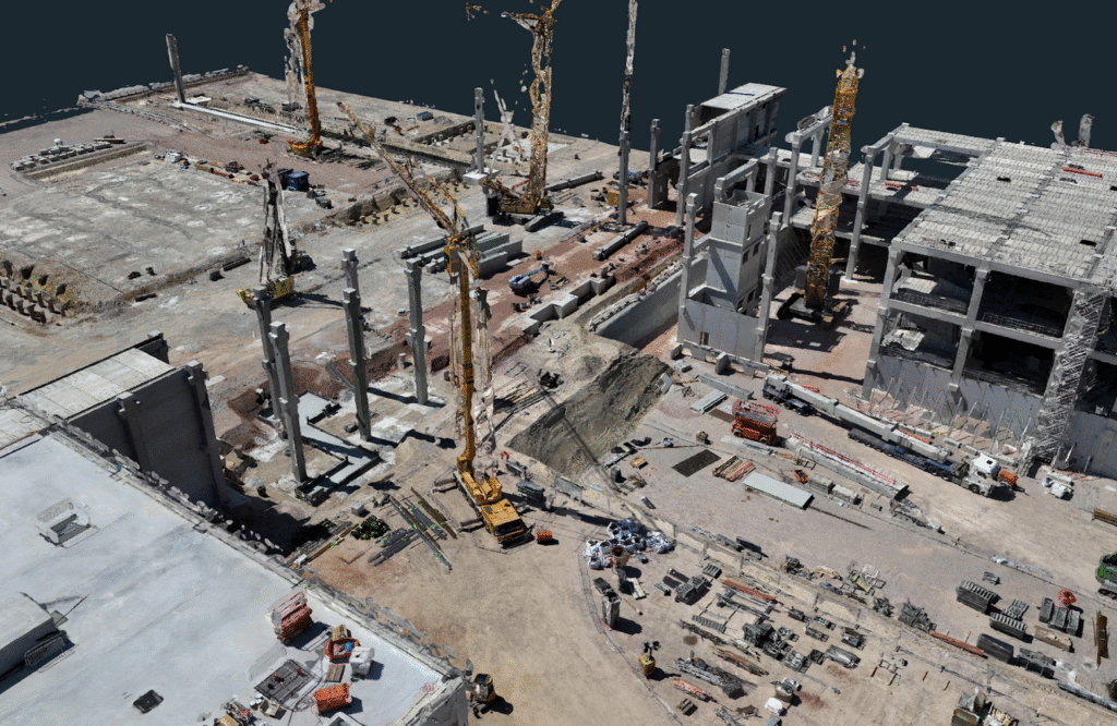
1. Volume Calculations & Stockpile Management
Need to calculate volumes in a quarry or stockpile yard? What used to take hours or days with traditional tools can now be done in under 30 minutes using drone photogrammetry. No ground contact needed — just fly, process, and measure.
Stockpile volume calculation as a top use case for drone photogrammetry.
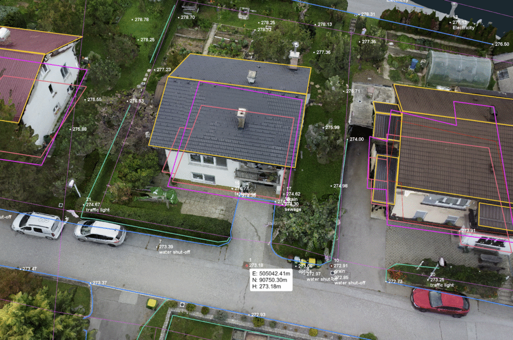
2. Survey Mapping
Traditionally, surveyors decide in the field what to measure using GNSS or total stations. But what if you forget something?
With drone photogrammetry, you capture everything at once. A 10-minute drone flight can cover 200m x 200m and generate all the 3D data needed for CAD mapping — roads, curbs, utilities, and buildings included.
Climbing rooftops is a thing of the past. In just 10 minutes, a drone can capture 500+ high-resolution images of a roof from all angles. Using photogrammetry software, you can generate precise 3D models for accurate solar panel placement. Safer, faster and more accurate.
Drone photogrammetry is becoming a must-have tool in the solar industry.
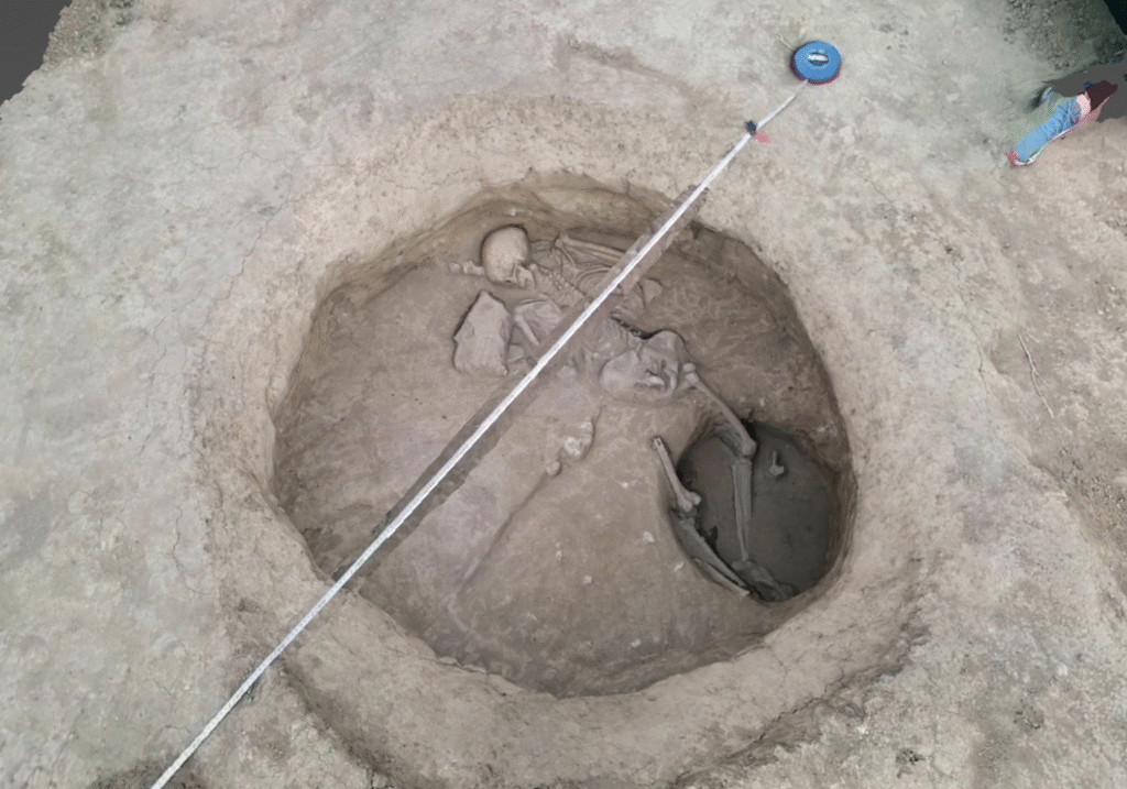
5. Archaeology & Cultural Heritage
Preserving cultural sites is easier with UAV photogrammetry. Archaeologists can now create highly detailed 3D reconstructions of excavation areas and monuments, supporting long-term conservation and digital archiving. This technology supports:
Spatial analysis
Restoration planning
Public outreach and education.
Drone photogrammetry for Archaeology.
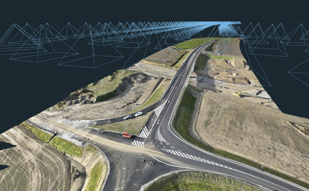
6. Road & Railway Mapping and Inspection
Surveying roads or railway lines using GNSS or total stations often involves traffic disruptions and safety risks.
With aerial photogrammetry using drones, you:
Don’t interrupt traffic
Avoid safety hazards
Capture large areas quickly
Achieve higher data completeness
It’s more efficient, safer, and far more scalable.
Road mapping in 3Dsurvey.
Conclusion
Whether you’re a land surveyor, construction manager, archaeologist, or solar panel installer, drone photogrammetry delivers clear advantages. It’s accurate, cost-effective, fast, scalable and visually rich.
If you’re still relying on outdated tools for field data collection, now is the time to level up. Embrace UAV photogrammetry and unlock a new world of efficiency and insight.