Stockpile volume measurement with integrated LiDAR
Key takeaways
Combining drone photogrammetry and LiDAR data allowed accurate volume measurement of large stockpiles.
Importing georeferenced LiDAR tiles into the same project streamlined processing and created unified dataset integrity.
Generation of DSM, meshes, and isolines enabled quick surface analysis, height gradients, and volume calculations.
The hardware-agnostic workflow supported both photogrammetric and LiDAR data in one tool, saving time and reducing field revisits.
The deliverables (volume reports, contours, DXF/CSV exports) provided actionable insights for mining and quarry operations needing frequent stockpile monitoring.
Introduction
Project: Stockpile Volume Measurement
Until a few years ago, stockpile volume measurement was a challenging and time-consuming task for the Polish surveying company GEOS3D. It required the involvement of multiple specialists, various surveying tools, and post-processing programmes.
However, with the integration of LiDAR technology and 3Dsurveysoftware, the process has become significantly faster and more efficient. This state-of-the-art solution allows for automatic point cloud generation and accurate surface modelling, which has significantly improved the daily workflow of the engineering team.
By importing the LiDAR data from a 3D scanner and creating a point cloud, surface calculation and using the integrated CAD tool, the company can now produce highly accurate results in a fraction of the time. What once took days or even weeks to complete, can now be completed in hours, enhancing both accuracy and efficiency. In addition, the ability to visualise and analyse the data in a single environment has significantly increased precision and reduced potential measurement errors.
Approach
Fieldwork
The fieldwork lasted one day and involved the use of three key technologies:
3D scanning (Leica RTC360): the laser scanner allowed fast and precise data acquisition of the geometry of the heaps and their surroundings.
LiDAR technology (DJI Matrice 350 RTK + Zenmuse L2): the advanced LiDAR system enabled accurate scanning of the site, including hard-to-reach areas.
drone photogrammetry (DJI Mavic 3E): images from the drone helped to complete the data, correctly identify each stockpile and create an accurate 3D model.
Some of the stockpiles were covered, making it impossible to use traditional aerial survey methods. In such cases, it was crucial to use a terrestrial scanner, which allowed an accurate representation of the structure of the object and its volume.
3Dsurvey processing
Data analysis and calculations
In order to get to know the surface calculation tool as well as possible, the GEOS3D team first read the tutorial posted on the 3Dsurvey website. In addition, the team attended a webinar organised by 3Dsurvey in December, which allowed them to gain additional information and useful tips to perform the task as efficiently as possible.
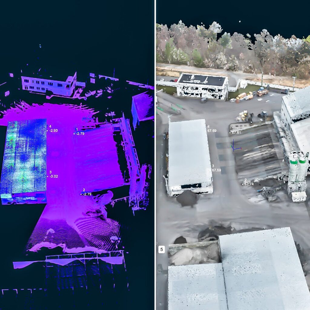
The first step in 3Dsurvey software was to combine the LiDAR data obtained from the drone and the ground scanner. Using the manual registration feature, this was easily accomplished. The combination of the two technologies allowed the team to create a single, consistent 3D model that contained full information about the geometry of the stockpiles.
Combining LiDAR data from the drone and terrestrial scanner with manual registration tool
The team then used the bounding box tool and cleaned the model of unwanted elements, such as roofs, excessive dust, and other objects in the stockpiles’ surroundings. This provided a readable model for further analysis.
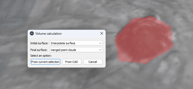
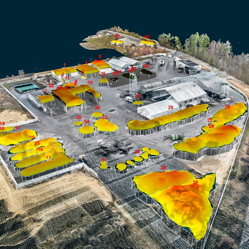
The next key step was to create a regular grid mesh DSM (Digital Surface Model). Each pile then had to be marked by outlining it and calculating the volume using the calculate volume function.
Volume calculation window
Based on the location of the stockpile, the team used different selection methods:
By contour: ideal for heaps with a regular shape
From a pre-drawn base of the pile in the CAD module: enabled them to accurately consider the shape of the object and avoid misinterpreting the walls of the covered warehouses where materials were also stored.
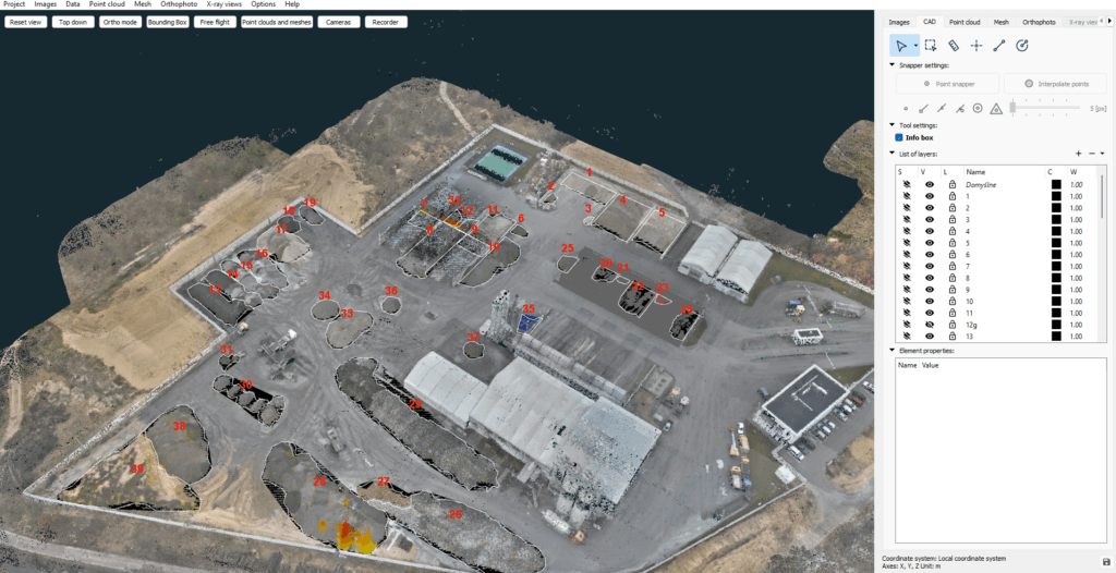
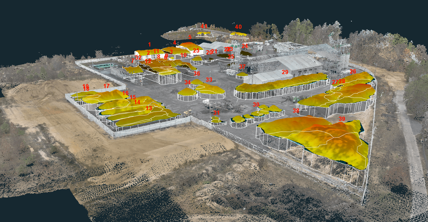
Outlined and numbered all stockpiles in CAD tab
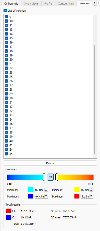
Once the calculations were completed, 3Dsurvey allowed the results to be viewed and edited immediately, which was very convenient and enabled the data to be verified on the fly.
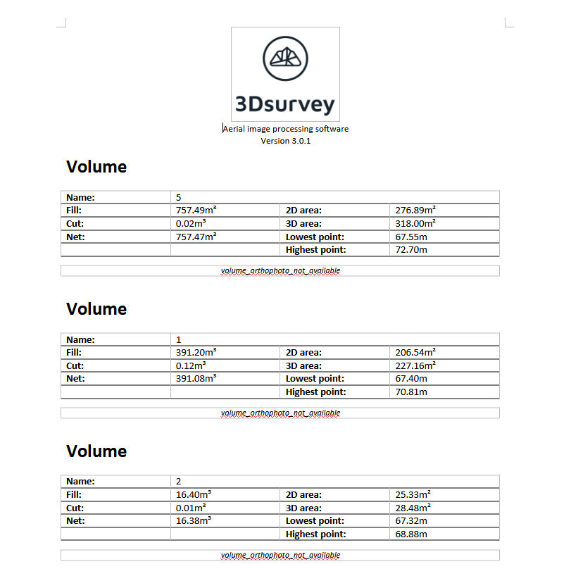
Volumes tab provides a quick overview of the calculation results
Report on Stockpile Volume Measurement
The client’s wish was to receive full reports on the volume calculations of each heap. 3Dsurvey was perfectly up to the task. With a few clicks, the software produced ready-to-use reports containing all key information, which were then sent to the client in the form of a clear PDF document. The ability to automatically generate the reports significantly streamlines the whole process and enables results to be delivered quickly.
The analyses and calculations on stockpile volume measurement showed that 3Dsurvey is an extremely effective solution for this field task. Thanks to the use of modern measurement technology and intuitive software, it was possible to significantly reduce working time and increase the accuracy of results. The data obtained was not only precise, but also easy to interpret and present in the form of reports.
The benefits
The implementation of 3Dsurvey has brought GEOS3D a number of benefits, including:
Reduced measurement time – the entire process, which previously took several days, was reduced to one day of fieldwork and several hours of data analysis in the office.
Increased measurement accuracy – the combination of LiDAR and TLS data has produced extremely precise results.
Ease of use – intuitive tools and the ability to quickly generate reports made the team’s work much easier.
Flexibility – the ability to combine data from different sources and edit it in the CAD module allowed the analyses to be tailored to the specific requirements of the client.
In summary, the use of 3Dsurvey proved to be the perfect tool. The all-in-one software not only improved the stockpile volume measurement, but has also allowed GEOS3D to be even more efficient and precise in carrying out similar projects in the future.
Stockpile volume calculation
Content provided by GEOS3D, a team of Polish surveyors providing a full range of surveying services from 3D scanning to drone operations.