Architects and engineers are often dealing with heritage conservation projects. The fundamental need of any conservation project is understanding the object and gathering data about its physical condition prior to any action and intervention that might change the object.
Each object has its own unique characteristic and based on its physical condition, time and needed accuracy for the project, professionals decide which documentation approach or tool is the most appropriate.
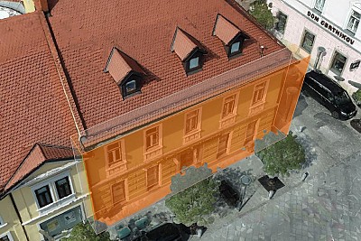
In this webinar Marko will show on a real case project how photogrammetry is a great cost-efficient option for reconstruction projects, especially perfect for old rocky buildings, because of its incredible texture. This way user gets large amounts of data in 10 times less time spent on the field (compared to traditional way of surveying with toll station), high accuracy of the 3D model and usage of low cost and portable equipment. With this 3D documentation the building is archived and can be used for all reconstructions in the future.

