Key takeaways
2D images lack depth; converting to 3D restores measurable geometry
3D models enable accurate volumes, slopes, and positions—reducing fieldwork and rework
Photogrammetry uses overlapping photos + triangulation to reconstruct 3D scene
Including GCPs and RTK/PPK data ensures survey-grade accuracy
3Dsurvey supports images, LiDAR, SLAM, and 360° data in one project
Output includes point clouds, meshes, DSM/DTM, orthophotos, contours and CAD measurements—all inside one tool
Applications span land surveying, construction, mining, environmental engineering
Professionals choose 3Dsurvey for an integrated, accurate, all-in-one workflow
Introduction
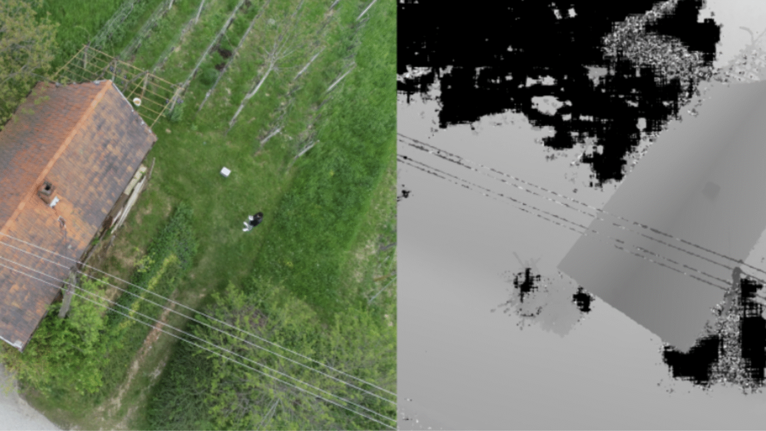
Every image begins in two dimensions, width and height. A 2D photo captures appearance but not depth, meaning distances, and volumes remain unknown. To measure, analyse, or model the real world accurately, that missing third dimension must be restored.
When you convert a 2D image to 3D, flat visual data becomes spatial information. Surfaces gain geometry, depth can be measured, and relationships between objects become quantifiable. This transformation is what allows professionals to move from seeing an image to truly understanding the physical space it represents.
Why converting 2D images to 3D matters?
In professional surveying and construction, accuracy defines every decision. Working only with 2D images limits what can be measured or verified. Distances are estimated, heights are unknown, and real-world geometry is flattened into a picture that looks clear but lacks precision.
When a user converts a 2D image to 3D, one moves from visual reference to measurable reality. The difference is practical:
- volumes can be calculated,
- slopes checked,
- and positions verified directly from the data.
This reduces time on site, prevents costly rework, and allows every stakeholder, from surveyor to project manager, to rely on the same accurate model. So the fastest way to convert 2D image to 3D is with a photogrammetry software like 3Dsurvey, of course.
How 3Dsurvey converts 2D images into 3D models?
Photogrammetry is the science of calculating 3D geometry from overlapping photographs. When each part of the scene is visible in several images, the software can identify shared features and reconstruct their position in space using triangulation. The higher the image overlap, the more detail and accuracy the final model achieves. If you want to know more, we have a blog post about how does Photogrammetry Software work that you can read. But to ensure georeferenced precision, surveyors often include Ground Control Points (GCPs – clearly marked reference targets with known coordinates) that anchor the entire model to real-world measurements.
3Dsurvey applies this principle to process images from any camera, (aerial, handheld, or terrestrial) and build accurate, scaled 3D representations of the environment. Through its photogrammetric engine, the software automatically detects common points, aligns photos, and generates dense, survey-grade 3D data. This makes it possible to convert 2D image to 3D efficiently and reliably. Read more on how to make a 3D model in 5 steps.
What sets 3Dsurvey apart?
What sets 3Dsurvey apart is its ability to combine data from different sources inside a single project. Alongside image-based photogrammetry, users can import and merge LiDAR scans, SLAM mobile mapping data, and 360° imagery. All datasets align within the same coordinate system.
This gives surveyors and engineers a complete, unified 3D environment that reflects the site as it truly is and also adds additional benefits of cross-check, data overlap and enhanced inspection options.
Ensuring accuracy with survey data
Converting images into 3D geometry is only valuable when the results are accurate and repeatable. In professional surveying, every model must align precisely with real-world coordinates, and 3Dsurvey ensures this through its full support for Ground Control Points (GCPs) and RTK/PPK data.
GCPs act as physical anchors between the digital model and the actual site. By marking a few known positions on the ground and including them in the photo set, surveyors allow the software to correct and scale the 3D model precisely. When working with drones or GNSS-enabled cameras, 3Dsurvey also reads RTK or PPK data, combining positional accuracy with efficient fieldwork.
Coordinate systems within 3Dsurvey
All spatial data inside 3Dsurvey follows the same coordinate system, guaranteeing that every dataset fits together. Whether it comes from aerial images, LiDAR scans, or SLAM mapping.
Even if sources are in different coordinate systems, 3Dsurvey will set them to the desired one, by using the Manual Registration feature. This consistency is what gives professionals confidence that when they convert 2D image to 3D, the output can be trusted for measurement, documentation, and engineering use.
From 3D models to measurable results
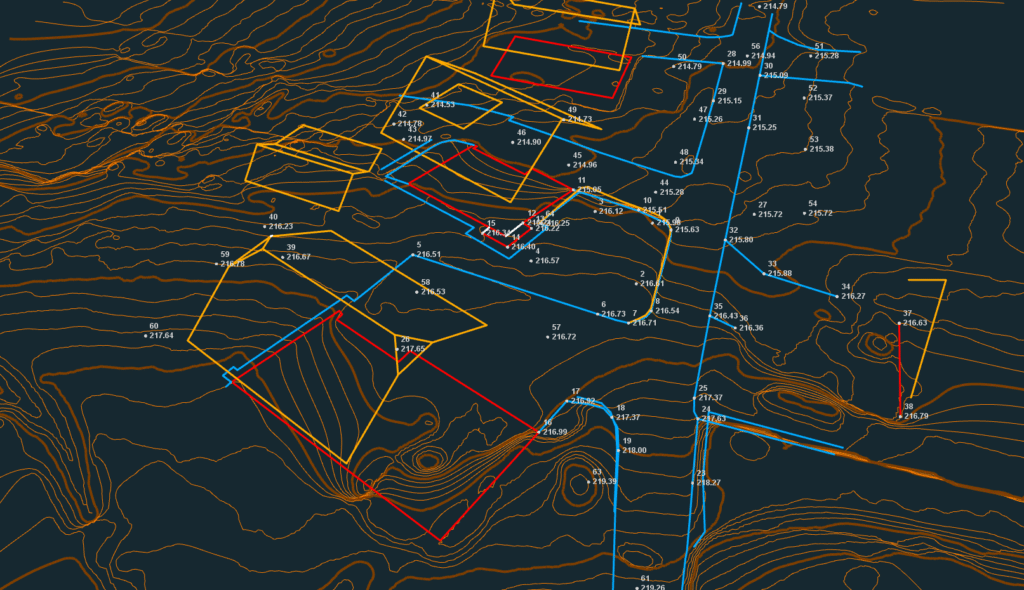
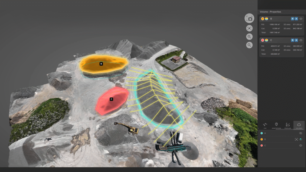
As mentioned before 3Dsurvey turns raw spatial data into practical, measurable results. The software generates dense point clouds and 3D meshes that represent the surface in full detail, along with Digital Surface Models (DSM) and Digital Terrain Models (DTM) for elevation-based analysis. From the same dataset, it produces both traditional and true orthophotos. A precise, georeferenced 2D map derived from 3D data that remains accurate across the entire area.
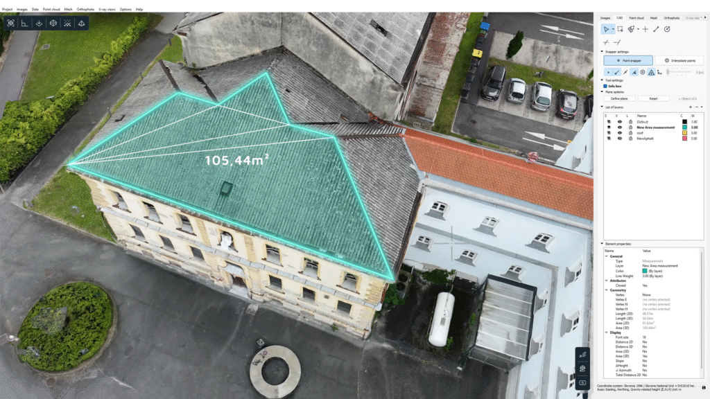
With built-in CAD tools (integrated CAD engine), users can immediately measure distances, areas, and volumes. They can also create cross-sections and profiles; and generate contour lines directly within the same workspace. There is no need (but is possible if required) to export into another program. Everything from surface modelling to documentation happens inside 3Dsurvey.
This integration saves time, eliminates file transfers, and ensures complete consistency between visual and numerical results. When professionals convert 2D image to 3D in 3Dsurvey, they move directly from raw imagery to deliverable outputs ready for engineering, design, or construction verification. All in a single, unified environment.
Real-world applications
Land Surveying
In land surveying, transforming images into 3D models enables faster and more accurate terrain mapping, boundary definitions, and feature extraction, empowering surveyors, GIS specialists, and planners with actionable results. The integration of photogrammetry, LiDAR and SLAM, and field-measured references allows teams to execute tasks with fewer field visits and less manual rework.
The case study of Facade mapping of the Ljubljana Central Market building will give you a good idea how and why this is important. Or if you are just starting in the land surveying industry, our blog post Land surveying 101 can be very helpful.
Construction
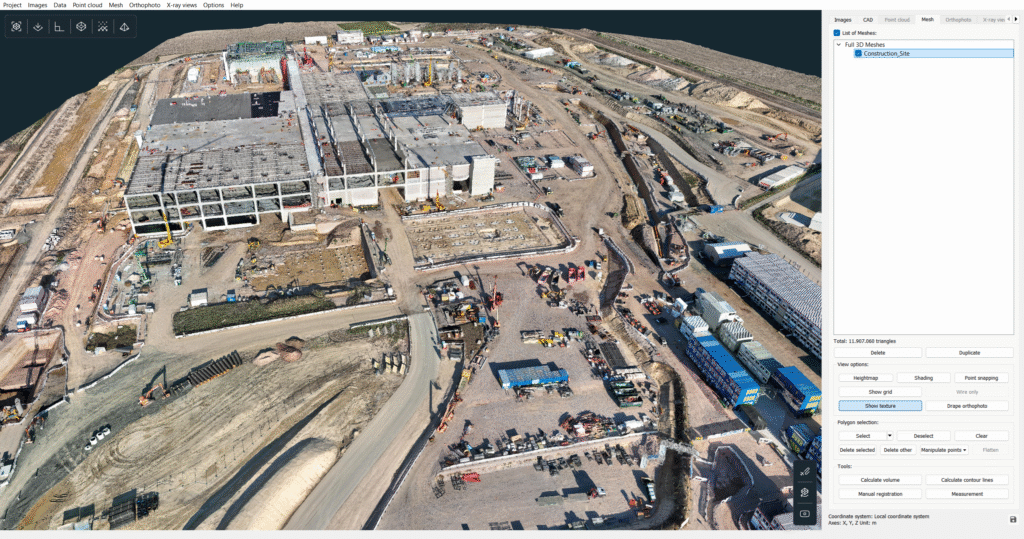
In construction workflows, the ability to convert 2D image to 3D drives efficiency in site planning, progress monitoring, and as-built documentation. With modelled surfaces and integrated CAD tools, teams can measure volumes, slopes, and dimensions directly inside the same platform, reducing hand-offs and misalignment between teams.
Our case study of Drawing building outlines using 3Dsurvey’s advanced CAD tools gets deeper into that.
Surface mining
For mining and quarrying operations, detailed 3D mapping derived from imagery supports tasks like
- designing pits,
- haul roads,
- tracking material stocks,
- and monitoring terrain changes.
The ability to integrate drone photogrammetry, LiDAR, and other data into one model enhances both accuracy and operational responsiveness.
A good example of that is the case study on Drone Mapping and Volume Calculation for Subsidence Repair.
Environmental & Engineering
In environmental and engineering projects, the need to convert 2D image to 3D is central to understanding terrain change, subsidence, or infrastructure performance. By locking spatial geometry, models become reliable bases for design, maintenance, and monitoring tasks.
To understand more, check how Oil tank construction monitoring in Denmark was done with the help of 3Dsurvey.
Why choose 3Dsurvey?
Professionals choose 3Dsurvey because it delivers everything they need in one connected environment. Instead of relying on multiple programs for image processing, CAD editing and reporting, users can manage the entire workflow, from import to final output within a single platform. This saves time, reduces data loss, and ensures that every result remains consistent and verifiable.
Developed and maintained in Europe, 3Dsurvey is available in 18 languages. It is built by surveyors who understand the daily requirements of fieldwork and data accuracy. The interface, tools, and outputs are designed to reflect real surveying practice.
3Dsurvey also enables professionals to combine and stitch together point clouds and imagery from different capture technologies like LiDAR, SLAM, photogrammetry, and even video. All datasets align in a single coordinate system, forming one unified 3D model. This integration gives users a complete spatial picture and ensures that every source contributes to a single, accurate reality model.
Its open export formats (DXF, LAS, and others) guarantee compatibility with existing engineering and design software. For professionals who need to convert 2D image to 3D and deliver precise, ready-to-use models, 3Dsurvey offers the most direct and dependable path from imagery to insight.
Conclusion
When you convert a 2D image to 3D, you don’t just create a visual model, you extract enormous amounts of information about the site or project. Every surface, measurement, and layer of data becomes accessible for analysis, design, and decision-making.
If your goal is to achieve survey-grade accuracy and a complete picture of your environment, 3Dsurvey offers a proven, all-in-one solution developed by professionals who understand real-world fieldwork.
You can try it for yourself. Download your 14-day free trial now!

