In this tutorial, you will learn how to use the CAD helper feature introduced in version 2.16 of 3Dsurvey. This feature allows you to position CAD points accurately using images from your survey data, enhancing precision in areas where the point cloud or mesh may not be as clear.
Why Precise Point Positioning Matters
Extracting details like road curbs, building corners, or roof ridges from point clouds or meshes can be challenging. With version 2.16, you can now select the exact position of your CAD vertex on the original images and triangulate for the most accurate placement.
Positioning CAD Vertices on Captured Images
Once in our CAD tab, simply select the line tool and start drawing anywhere. You will see a column of images (image side pane) docked to the left side of your screen. You can resize the pane or even undock it for better workflow if you would like to move it to another screen.
The point you just created is represented by a red glowing crosshair on the image. The name of the images are visible in the upper left corner of each image. As you move around the model and change your point of view, the images shown in the side pane also change. They are displayed to show you the chosen point from the angle that is most similar to your current point of view.
Navigating Images
With your cursor over the image, you can zoom in using your mouse wheel. Above the images there is also a slider to zoom in and out of all your images simultaneously. The three icons on top of the image pane let you choose the number of image columns displayed – from 1 to 3. To scroll down the list of images, hold CTRL while using the mouse wheel or use the slider on the right.
Improving Accuracy by Triangulating Points Across Multiple Images
To reposition your point on an image simply click and drag it to your desired position. The more times you repeat this step on various images, the greater the accuracy. The key is to determine the position from various perspectives – two or three observations are usually enough.
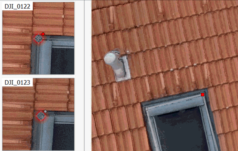
Visual Feedback: Crosshair and Observation Markers
The red crosshair represents your point on the image, with a glowing red dot indicating an observation for that image.
If you’ve made a mistake, simply right click on the crosshair and select “delete this observation”. When you are satisfied with the results you can simply close this window by clicking the x button. The images side pane is now minimized and accessible by clicking the icon shown below.
Advanced Right-Click Options for Observations
Other additional options are available when right clicking the crosshair. For example “Delete other observations for this point”: observations on other images are discarded, while the active one remains. The third option will “Delete all observations for this point” and reset its original position. The last option will delete all your observations, but keep the amended position of your vertex.