Key takeaways
- No need for a “Software Stack”: 3Dsurvey runs an all-in-one workflow. Image processing, CAD vectorization, volume calculation, and terrain extraction happen in one environment. No plugins, no format conversions.
- True Ownership: We still offer a perpetual license option. Buy it once, own it forever, and keep your data private on your own hardware.
- Human-Led Onboarding: Most beginners fail because of workflow gaps. We provide 1-on-1 training and a personal support manager to ensure your first project crosses the finish line.
- Native CAD Integration: You don’t “export to CAD”, you vectorize directly on point clouds, 3D meshes and orthophotos within the software, then export a finished DXF.
Where beginners actually bleed time?
The best photogrammetry software for beginners isn’t the one with the flashiest marketing; it’s the one that keeps you from drowning when you switch from rods and prisms to drones.
In the field, you deal with mud and deadlines. In the office, beginners usually hit a wall of “too many options.” You end up with a UI that feels like an airplane cockpit when you just want a clean deliverable. 3Dsurvey is built for a surveyor’s reality: capture, process, measure, and deliver without juggling three different apps and a prayer. Plus, our default settings are optimized for 90% of standard surveying projects right out of the box.
Why beginners struggle moving from a traditional approach to drones?
Transitioning to drone mapping often uncovers three major pain points that bleed time and kill accuracy:
- Weak Control Strategies: Without a clear path for GCPs and checkpoints, you get surprise errors at the end of a long processing run.
- Messy coordinate system handling: Moving data between processing engines, CAD, and GIS usually leads to “shifted” data.
- Manual CAD rework: Exporting to external CAD tools often disconnects your linework from the original 3D source data, making errors hard to spot and repair.
3Dsurvey keeps the chain tight. You process the imagery, generate the surfaces, and then vectorize and measure inside the same environment.
Why is 3Dsurvey the best photogrammetry software for beginners?
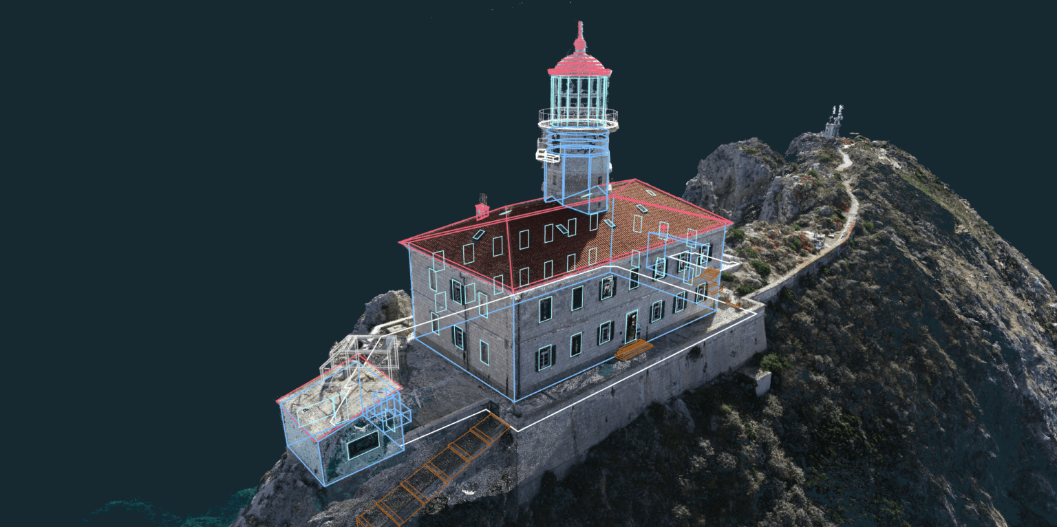
1) The CAD work happens within same software
This is where most beginner workflows break. Usually, you process in one tool, export a massive file, and then fight with snapping and surfaces in an external CAD program.
3Dsurvey’s integrated CAD workflow allows for direct vectorization on:
- Point clouds and 3D meshes
- Digital Surface & Terrain Models (DSMs/DTMs)
By keeping CAD inside the engine, you ensure that every line you draw is snapped exactly to the high-resolution source data.

2) A workflow that grows with you
Our default workflow follows the exact sequence a surveyor uses in the field. However, 3Dsurvey doesn’t trap you in a “beginner” mode. As you gain experience, you can fine-tune parameters for complex sites or specialized mining projects.
Because it’s built for integration, you aren’t locked into photogrammetry. You can bring in LiDAR point clouds, GNSS control data, and existing CAD datasets (like property boundaries) to work with them all as a single, unified dataset.
3) Professional ownership and data privacy
The industry is moving toward “subscription-only” models that hold your data hostage. We disagree. 3Dsurvey offers a perpetual license, giving you full control over your costs and your data. Since the processing happens on your machine, your project remains private and secure—no forced cloud uploads required.
4) Real support in the transition phase
For a surveyor moving to drones, support is an essential safety system. “Beginner-friendly” doesn’t just mean a simple UI; it means having an expert to call when a project looks sideways.
- All plans include technical support from people who understand surveying.
- You get a free 1:1 online training session to set up your first project.
Conclusion
If you’re a traditional surveyor moving into the drone space, your first win needs to be boring: repeatable workflows, predictable outputs, and confidence in the final accuracy. 3Dsurvey is the best photogrammetry software for beginners because it prioritizes CAD deliverables and human support over software “fluff.”
Start your 14-day free trial today, it’s fully functional, requires no credit card, and gives you everything you need to prove your drone workflow works.
If you need more persuading, we invite you to read about Why 3Dsurvey is the Best Photogrammetry Software in 2026 and get a complete picture on everything our software has to offer.

