Creating 3D models using videogrammetry
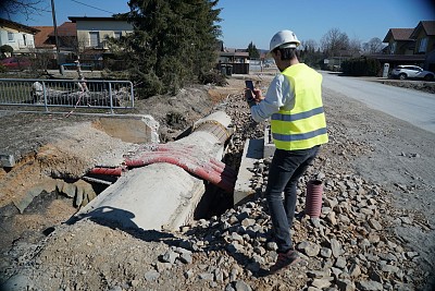
Surveyors often face a common challenge: arriving on-site too late—after infrastructure has already been covered or backfilled. This results in missing or inaccurate measurements, leading to costly consequences such as the need for excavation or the risk of hitting underground utilities like power lines or water pipes.
Avoid Costly Mistakes with Proactive Documentation
In this webinar, we’ll show you how to avoid these problems before they happen. Using 3Dsurvey’s videogrammetry workflow, you can capture infrastructure efficiently and create precise 3D models—before any backfilling or paving occurs. This allows for documentation without needing a surveyor immediately on site.
What You’ll Learn
We’ll walk you through how to:
Capture video data efficiently
Perform videogrammetry to generate 3D models
Process and analyze data using 3Dsurvey
Validate the accuracy of your models
Real-World Use Cases
We’ll demonstrate the workflow using four practical examples:
Urban Infrastructure: Documenting a city’s drinking water pipeline installation
Stockpile Measurement: Calculating volume of a material pile
Interior Mapping: Creating detailed 3D models of indoor spaces
Fun Bonus: Modeling our CEO’s head in 3D (we’re especially excited about this one!)
Webinar Details
7 April 2022 at 14:00 CET.

