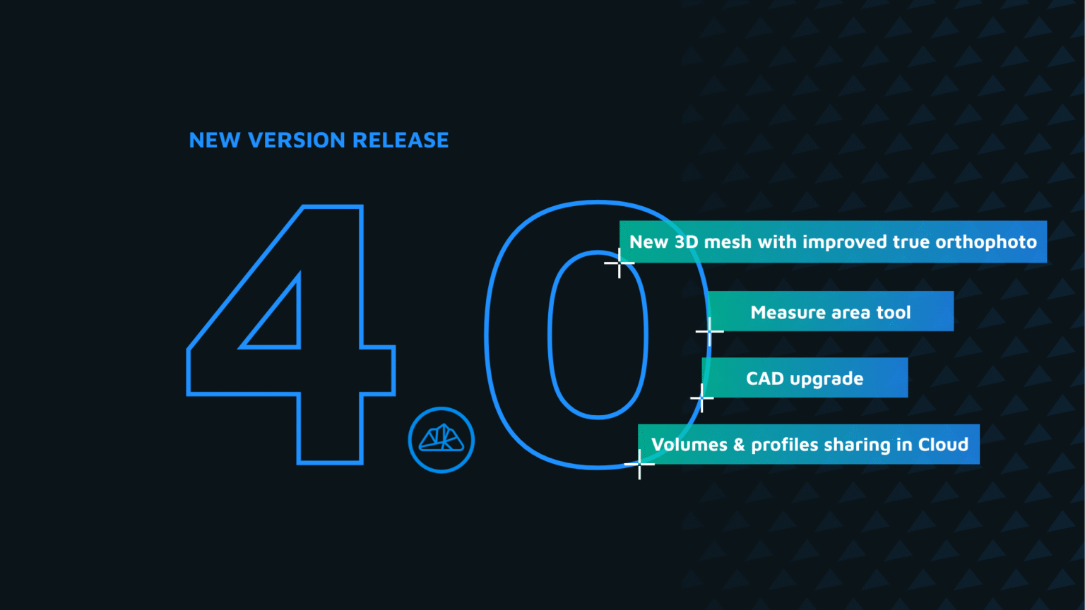
1. New 3D Mesh
We’ve completely rebuilt the 3D mesh engine in 3Dsurvey 4.0 with state-of-the-art algorithms that push detail extraction to a new level. The result offers the sharpest, most reliable mesh in the history of 3Dsurvey.
What’s new:
- Building edges stay sharp without the “ballooning” effect.
- Thin objects like powerlines, traffic lights, and road signs are captured more realistically.
- Low-texture surfaces (concrete, asphalt, walls) generate smoother, more accurate geometry with virtually zero noise.
Why it matters:
- Your outputs (orthophotos, profiles, CAD extractions, volume measurements) start from a cleaner, more precise foundation.
- Less time wasted fixing messy geometry in CAD means faster delivery and fewer site revisits.
- You deliver results that are sharper, clearer, and ready to use right away.


2. Improved True Orthophoto
True Orthophoto generation in 3Dsurvey 4.0 has taken a big step forward thanks to the new 3D Mesh. Roof edges are now sharp and accurate, eliminating the “balloon” effect that often distorted buildings in earlier outputs. Small details close to structures (such as manholes, curbs, or utilities) remain clearly visible instead of being blurred or hidden, making them easy to identify and extract with CAD tools. Even dense urban areas with tall buildings now produce consistent, high-quality true orthophotos, giving surveyors reliable visibility of the features that matter for planning and design.
This means less time correcting geometry in CAD, faster project delivery, and greater confidence when documenting complex urban environments. For example, in a city-center survey you can now precisely capture a curb line or a manhole cover right next to a tall building — details that used to be lost are now preserved as part of your deliverable, ready for measurement and design.

3. Measure Area Tool
Measuring 3D areas in 3Dsurvey has always been possible using closed polygon lines, but in version 4.0 we’ve taken it to the next level. A new dedicated Measure Area tool, powered by an improved algorithm and clearer visualizations, makes area calculations faster, easier, and more accurate.
Whether you need to measure a roof surface for solar panel installation or renovations, or calculate the size of material zones like asphalt, grass, or gravel for construction cost estimates, the tool delivers reliable results instantly. Simply activate the 3D Area Tool, outline the area of interest, and get precise measurements in both 2D and 3D.
4. CAD Upgrade
4.1 Length input:
In previous versions of 3Dsurvey, drawing an exact line meant dragging with your mouse, clicking, and then adjusting the line afterward to get the correct length. In 4.0, this process is much simpler: while drawing, just type the desired length on your keyboard and press Enter. The line is immediately created at that exact length in the direction of your cursor, no special mode required. This eliminates the need for “eyeballing” and correcting lines, ensuring every measurement is accurate from the start. This is perfect for parcel boundaries, construction layouts, and floorplans. For example, when mapping a parcel, you can click the corner, type 25, and press Enter to instantly draw a 25 m boundary line.
The best part is that this tool also allows you to draw sides of objects that couldn’t be fully captured on the ground with photogrammetry or traditional measurements. Sometimes corners are hidden, but if you know an object is 5×7 m, you can click three visible corners on the mesh or point cloud, enter the correct length, and automatically construct the fourth corner to complete a precise rectangle. This functionality is a game-changer for creating accurate CAD models from incomplete data.
4.2 Trim / Extend / Intersect Tool:
The Trim, Extend, and Intersect tools in 3Dsurvey 4.0 make adjusting line segments in your CAD drawings faster and more intuitive. With the Trim/Extend tool, you can quickly shorten or lengthen lines so they meet other geometries, simplifying cleanup and alignment tasks in complex vector layouts such as parcel boundaries, road networks, or contour intersections. These tools are especially invaluable when extracting building floorplans using automatic line detection on X-ray views, allowing you to create precise, clean CAD geometry with minimal effort.
Instead of manually adjusting or redrawing lines, you can now quickly snap, trim, or extend lines to match surrounding geometry, saving time and reducing errors. This ensures your CAD outputs are accurate, consistent, and ready for further analysis or design work.
4.3 3D Perpendicular & Perpendicular Snapper:
3D Perpendicular
Take your CAD drawings into 3D with 3Dsurvey 4.0. The new 3D Perpendicular tool allows you to create accurate 3D wireframe models for BIM, building layouts, or interior design. Start by drawing the footprint of a building or room using the drawing on plane feature, then use 3D Perpendicular to extend the wireframe vertically and capture the full 3D geometry. Combine it with the Length Input tool and other CAD features to design precise 3D objects and elements directly from your mesh or point cloud data.
Perpendicular Snapper
We’ve also added a new snapper option to make drawing perfectly perpendicular lines effortless. With the Perpendicular Snapper, your drawing lines automatically align perpendicular to the target line, ensuring accurate, clean geometry without manual adjustments. This is ideal for creating orthogonal layouts, floorplans, or structural elements that require precise right angles.
Why Perpendicular matters:
These tools streamline 3D CAD modeling, reducing manual corrections and helping you generate fully accurate wireframe models faster. Whether you’re preparing building models, interior layouts, or BIM-ready deliverables, 3D Perpendicular and the new snapper make your workflow smoother, more precise, and more efficient.
5. Auto Rotate Presentation
Show off your 3Dsurvey models with ease using the new Auto Rotate Presentation feature. With a single click, your model starts rotating automatically around the center cross in the current view perspective. You can adjust the angle and zoom while the rotation is in progress, giving you full control of the presentation. If you pan the model, the rotation stops instantly. This simple yet powerful feature makes it easy to showcase your 3Dsurvey results to colleagues, clients, or stakeholders in a smooth, dynamic, and visually engaging way.
Instead of manually rotating the model for demonstrations or screenshots, Auto Rotate Presentation lets you present your data seamlessly, highlighting every detail of your 3D model with minimal effort. It’s perfect for meetings, presentations, or quick internal reviews, making your results immediately clear and impressive.
6. Volumes & Profiles sharing in Cloud
3Dsurvey Cloud just got even more powerful! In addition to sharing 3D models, you can now upload and share profile lines and volume measurements directly via 3Dsurvey Cloud. Simply upload your project from the 3Dsurvey desktop software to your Cloud storage, and instantly share the results with clients or colleagues. No special software or high-performance computer is required on the recipient’s side — they can view profiles, volumes, and other results directly in a browser on a phone, tablet, or computer.
Ready to go?
Version 4.0 is available to all existing users with an active 3Dsurvey Yearly Support & Upgrades extension, or active Subscription license.
Version 4.0 is also available for trial for all previous trial users and existing customers with inactive Support & Upgrades.