• Home
  • Webinars
  • How to use drone and phone camera images in one project

How to use drone and phone camera images in one project

Telemetry of the drone images taken of a building that needs renovation
How to use drone and phone camera images in one project

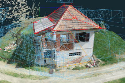
In some situations you may want to improve your 3D model captured by UAV images with close range images taken by phone camera or standard digital camera. With combining this images textured 3D models are more precise, without any blind spots and with more detail.

In the next webinar Marko will show you how to properly capture images and combine them in order to get quality results in 3Dsurvey.

Facebook
X
LinkedIn

Subscribe to our newsletter

What’s new in the field? Stay up to date with our newsletter!

VOTE NOW

Geo Week 2026 Game Changers Showcase

Vote for 3Dsurvey

Unlock a discount code to attend Geo Week

Days
Hours
Minutes
Seconds

You will be redirected to geo-week.com

Back On Track

50% on updates

Offer valid until 24th March.