Complete Workflow from field to project finish
Data captured from UAV’s has been in the industry for a while now, but a key part of any new technology is how to use it effectively.
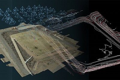
More importantly is understanding how the new technology helps with everyday tasks. One of the tasks that UAV data can be most effectively used for is Topographic mapping. Using UAVs for this purpose dramatically reduces field time, increases details of the terrain captured, while maintaining a survey accuracy. Most organizations have existing standards for these projects established in their preferred CAD platform. This webinar will show a Field to Finish approach with data processed in 3Dsurvey presented in a popular CAD software.
Who should attend
This webinar is intended for Surveying and Mapping professionals, and both potential and existing 3Dsurvey users will benefit from attending. In addition, users with experience with other photogrammetry software will see why 3Dsurvey is a leader in surveying and mapping applications.
We will also present another project with data created from the new DJI M300 RTK with the Zenmuse P1 camera.
Webinar is hosted by our partner Surveyors Source LCC from Arizona, US.

