What’s the difference between 3D photography and photogrammetry?
Key takeaways
3D photography (stereoscopic photography) creates the illusion of depth by capturing two slightly different images — similar to how our eyes perceive the world.
There are several ways to capture 3D photos, including stereo cameras, dual-shot techniques, and digital depth mapping with modern sensors or AI.
Viewing 3D photos requires special tools like 3D glasses, VR headsets, or lenticular prints to deliver a realistic depth experience.
3D photography focuses on visual immersion and aesthetics, commonly used in entertainment, art, and visualization.
Photogrammetry, in contrast, focuses on measurement accuracy — reconstructing real-world geometry for surveying, construction, and engineering purposes.
3Dsurvey’s early experiments with 3D photography from ultralight planes in Ljubljana demonstrated how stereoscopic imaging can capture striking spatial detail.
What is 3D photography?
3D photography (also called stereoscopic photography) is a technique that creates images with the illusion of depth, making them appear three-dimensional—much like how we perceive the real world.
Here’s how it works. Human eyes see the world from slightly different angles — your left and right eyes are about 6.5 cm apart. The brain combines these two slightly different images to perceive depth and distance. 3D photography mimics this by capturing two images of the same subject from slightly different perspectives (just like your eyes).
There are several ways to capture and view 3D photos:
Stereo Cameras: Use two lenses placed side by side to capture both left-eye and right-eye views simultaneously.
Dual-Shot Method: Take two photos of the same scene — one slightly shifted to the right — and combine them later using software.
Depth Mapping (Digital 3D): Modern smartphones and cameras use sensors or AI to create a depth map, which can generate a 3D-like effect or even allow “portrait mode” background blur.
Viewing 3D photos
To see the 3D effect, you need a way to show each eye its corresponding image:
3D glasses (red-cyan anaglyph, polarized, or shutter types)
3D displays or VR headsets
Lenticular prints (physical photos that change when you tilt them)
Where it's used?
The most common use cases are:
Entertainment (3D movies, VR, AR)
Scientific visualization (microscopy, astronomy)
Real estate, product design, and heritage preservation
Artistic and creative photography
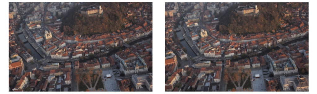
In 2012, during the development of 3Dsurvey software, we actually also spent some time with 3D photography and created some stunning stereoscopic models of Ljubljana city centre captured from an ultralight plane.
3D photography stereopair of Ljubljana city centre taken from an ultralight plane.
After inserting these two images into a cardboard stereoviewer we were able to see a 3D model with some surprising details.
What’s the difference between 3D photography and photogrammetry?
At first glance, 3D photography and photogrammetry might seem similar — both involve creating three-dimensional visuals from images. However, their goals, methods, and applications are quite different.
3D photography: Creating the illusion of depth
The main purpose of 3D photography is to produce an image that appears three-dimensional, giving the viewer a sense of depth. It’s primarily focused on visual experience, not measurement accuracy.
3D photography is most commonly used for marketing, entertainment, and visualization — anywhere you want to impress viewers with lifelike imagery or immersive visuals.
Photogrammetry: Reconstructing reality in true 3D
Photogrammetry, on the other hand, is a scientific and engineering method for reconstructing real-world objects or environments in true 3D geometry. Instead of using just two stereo images (as in 3D photography), photogrammetry relies on multiple overlapping photographs taken from different angles.
Using standard photogrammetric processing workflows, these images are transformed into:
3D point clouds
Realistic 3D meshes
Digital orthophotos
From these outputs, you can perform accurate 3D measurements, extract CAD data, and achieve survey-grade precision.
Because of its accuracy and scalability, photogrammetry is widely used across surveying, construction, mining, forensics, and other technical industries where reliable spatial data is essential.
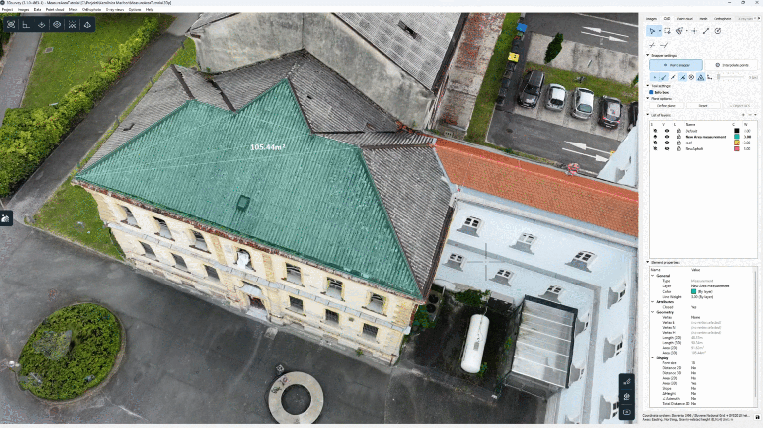
The new Measure area tool is part of our software version 4.0. With it you can measure real-life distances.
If you would like to get a deeper understanding about how photogrammetry software works, feel free to read our blog.
Otherwise we invite you to try our software free of charge for 14 days, no credit card needed. Start your 3Dsurvey journey now!