
What is CAD software?
CAD software (Computer-Aided Design) is a tool used to create, edit, and analyze precise 2D and 3D technical drawings and models, and is commonly used in surveying, architecture, engineering, and construction. In the modern era of geospatial data and digital workflows, CAD software has become an essential tool for surveyors and construction professionals. As expectations for speed, precision, and adaptability rise, it is critical to work with a platform that not only keeps up but leads the way.
3Dsurvey, a photogrammetry and mapping solution developed by surveyors, has steadily expanded its integrated CAD drawing software capabilities to support advanced workflows like vectorization, plan generation, volume calculations, and much more.
This blog takes a technical deep dive into the integrated CAD software features inside 3Dsurvey, focusing on its tools, workflows, benefits, and practical use cases for professionals who need power, simplicity, and precision in one platform.
Why 3Dsurvey Built Its Own CAD Software Features?
Many surveyors struggle with jumping between multiple platforms:
- one for 3D reconstruction,
- one for drafting,
- one for analysis,
- and another for measurements.
The team behind 3Dsurvey recognized that switching software introduces inefficiencies, errors, and training overhead. Our response: build CAD software inside the core 3Dsurvey environment, fully integrated with point clouds, DSMs, textured meshes and orthophotos.
The goal? To give users the ability to draw, edit, import and export vector data without leaving the photogrammetry environment – dramatically shortening the time from data collection to deliverable.
Top Features of the 3Dsurvey CAD Drawing Software
Line Drawing Tools
- Easily draw polylines in 2D or 3D views.
- Whether tracing over DSMs or vectorizing 3D structures, drawing lines is responsive and accurate.
- Users can apply snapping, layer control, and control line visibility.
Plane lock & Perpendicular lines
- Lock drawing to a specific height, define a custom plane, turn on the perpendicular mode!
- Elevate your drafts on a level of precision, achievable in no other photogrammetry software.
CAD Drawing with Image Support
- Draw directly on input imagery. This improves the precision of vector work because users can match features exactly as they appear on-site.
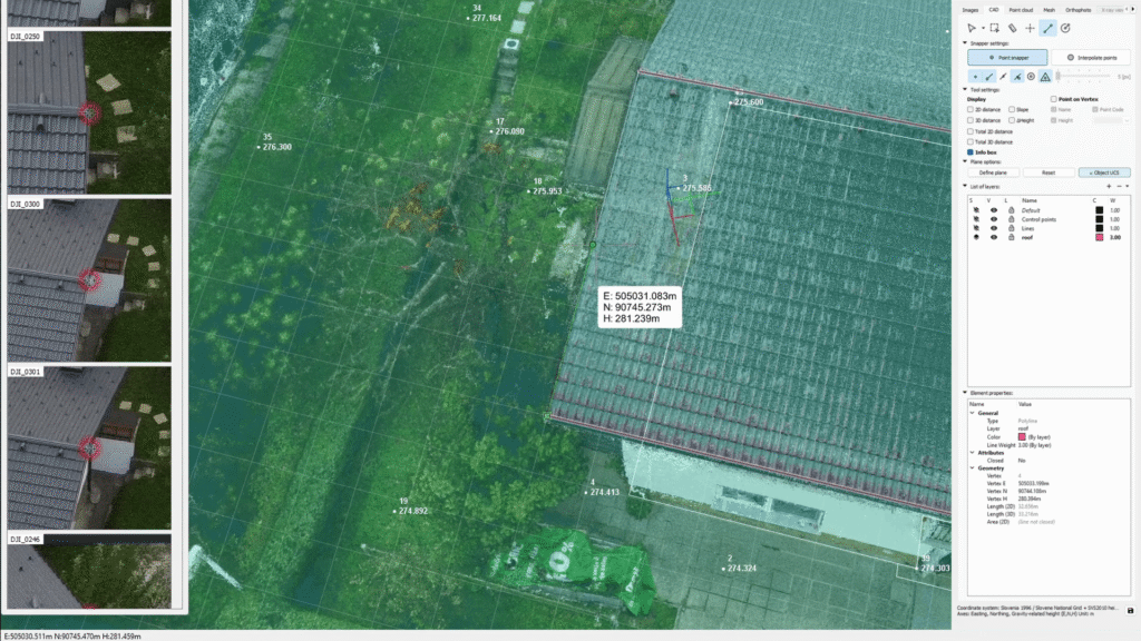
Project CAD onto Mesh
- A key workflow in 3Dsurvey’s CAD software features is the ability to “project” 2D CAD drawings onto a 3D mesh.
- This helps ensure vector lines are not dislocated, floating in 3D space, but follow terrain surfaces on true elevation.
Real-Time Measurement Feedback
- While drawing, the software displays line length, angles, and area in real time. This allows surveyors to validate results without switching tools.
- Snap Settings Snap to points, lines, intersections and more to make the ends meet.
Full Layer Control
- Organize your CAD vectors into named layers.
- Control colour, visibility, and export settings per layer to manage complex projects like road networks or infrastructure utilities.
CAD Export
- All drawings can be exported as DXF (and other formats), compatible with other CAD platforms.
- Coordinate systems and projection settings are preserved.
Vectorization Workflow in 3Dsurvey
One of the most critical tasks in any CAD drawing software is converting visual data into usable vector formats. 3Dsurvey allows users to vectorize directly on:
- DSMs and DTM grid mesh,
- 3D meshes,
- Point cloud (from SLAM, photogrammetry or other source),
- Orthophotos.
Users can, among other things, draw:
- boundaries,
- building outlines,
- roof edges,
- curb lines,
- fence lines.
Each drawing can be constrained by layers, snapped to features, and adjusted in real-time. The resulting data can be used for site plans, construction permits, or export to external BIM/GIS environments.
Use Case Example: Road Construction Plan Extraction
In one of 3Dsurvey’s tutorial, users were shown how to draw road centerlines, curb geometry, and sidewalk edges on orthophotos generated from drone data. The workflow involved:
- Calculating the DSM and orthophoto.
- Drawing centerlines with snapping and length validation.
- Assigning layers for sidewalk, curb, and road.
- Exporting the full set to DXF for engineering use.
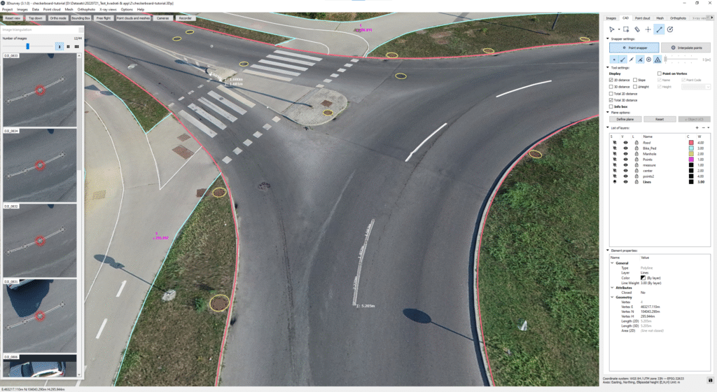
Snap Tools and Drawing Assistance
3Dsurvey’s snap tools include:
- Endpoint snap
- Intersection snap
- Midpoint snap
- Perpendicular/orthogonal snapping (coming soon)
- Point
- Mesh
- Circle
These are critical for achieving clean, connected geometry – especially in civil site design or urban feature extraction.
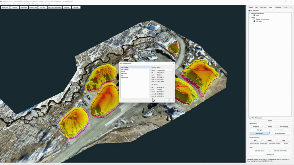
Volume Calculation via Closed CAD Polygons
A powerful companion to an integrated CAD software features is volume calculation. Once you draw or import a closed polygon around the area of interest (gravel pile, excavation pit, etc,..), 3Dsurvey computes:
- Volume above and below
- Cut/fill ratios
- Balance between excavation and fill areas.
This function is ideal for earthworks, construction prep, and terrain reshaping.
Free CAD Software Trial from 3Dsurvey
For users looking for a CAD software, you can get it within the 3Dsurvey software and try out advanced surveying CAD workflows. 3Dsurvey offers a free trial, where all CAD tools are fully enabled during the trial period, therefore allowing real-world evaluation before investing.
You can find some more information about the integrated CAD software here.

