Best Practices for Mission Planning with 3Dsurvey Pilot
In this webinar, we dive into practical tips and best practices for mission planning using 3Dsurvey Pilot, with a focus on optimizing data collection for various use cases. Whether you’re mapping for 2D orthophotos, calculating volumes, or creating detailed 3D models, this session provides actionable guidance for getting the best results from your drone flights.
What You'll Learn
- 2D Orthophoto Mapping (Single grid mission)
- Volume Calculations (3D-Focused Missions)
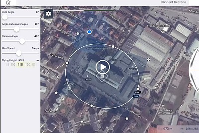
- 3D Object Modeling (e.g., Buildings)
- Road Mapping (Linear Mission Planning)
- Real-world project (3 km section of a 20 km cycling route)
Whether you’re just getting started or looking to refine your workflows, this webinar offers a clear and hands-on look at how to get the most out of 3Dsurvey Pilot in the field.

