Upgrade to the Latest 3Dsurvey Version
Maximize Your Efficiency!
Stay ahead of the competition with faster processing, enhanced accuracy, and new powerful tools designed for land surveyors, construction professionals, and mining experts. Each new version brings significant improvements that streamline workflows and boost productivity.
Why upgrade?
Key Features & Benefits
Quick highlight of the key updates.

X-ray Views in Scan Module

RTK Videogrammetry Integration

3Dsurvey Cloud Integration

Select by Color Tool

New Texture Enhancements

CAD Drawing with Image Support
Changelog
3Dsurvey version changes
Key Features and Improvements
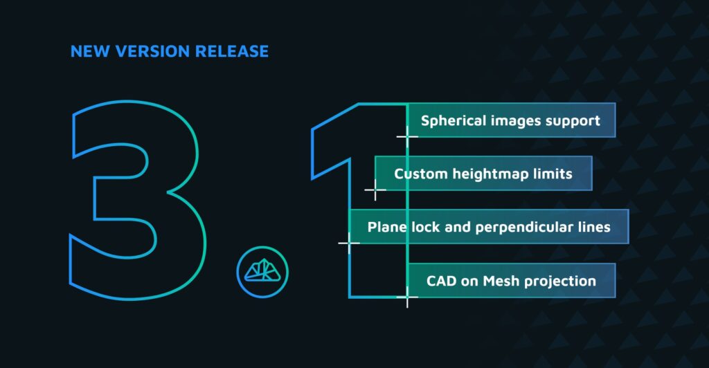
- Plane Lock and Perpendicular Lines: New CAD tools for precise vector drawing on locked height or user-defined plane. Great for sloped roofs, facades, or roads.
- CAD on Mesh projection: Snap 2D CAD plans directly onto 3D models for perfect alignment and integration.
- Contour Line Simplification: Cleaner, smoother contours—up to 3× smaller file sizes for better third-party CAD software compatibility.
- Custom Heightmap Limits: Tailor heightmap color scale to highlight critical terrain features.
- Spherical Images Support (Scan module): Easily import, view and work on spherical images aligned with your point cloud in 3Dsurvey
- Automatic Line Detection (X-ray Views): Auto-generate floorplans and outlines of structures from point cloud.
- Azimuth Measurement & Adjustable Decimals: Improved CAD precision and spatial orientation feedback.
- Updated SiteScan App: Expanded RTK videogrammetry support with new GNSS devices.
Land Surveyor Benefits
- New level of CAD precision for cadastral lines, building footprints, and elevation profiles.
- Optimized contours for faster integration into survey reports and GIS systems.
- Better feature clarity in elevation maps with custom heightmap control.
- Faster plan generation using automatic line detection.
- RTK videogrammetry upgrades streamline data capture with more supported GNSS devices.
Construction Worker Benefits
- Draw and project structural outlines like solar panels or roof plans directly on 3D models without compromises.
- X-ray enhancements improve floorplan extraction for documentation or permits.
- Combine spherical images and point clouds for intuitive indoor project inspection.
- Perpendicular CAD drawing makes it easy to draft wall layouts and utility alignments.
- Faster creation of accurate visuals for stakeholder presentations or as-built records.
Mining Benefits
- Heightmap customization enhances analysis of elevation-crutial areas like pits or dumps.
- Contour simplification reduces file size improves visual aspect and boosts performance in mine planning tools.
- Combine spherical imagery and CAD tools for immersive site documentation (also underground).
- CAD on Mesh projection allows seamless plan-to-surface alignment for excavation plans and safety maps.
- X-ray tools enable quick extraction of undrground fetures like mine tunnel layouts or infrastructure features.
- Use Plane lock to determine future extraction on a baseline condition 3D model.
Key Features and Improvements
- Coordinate System Upgrade (PROJ): Simplified selection and transformation of coordinate systems with presets and automatic geoid model integration.
- Automatic Machine Deactivation: Licenses are freed upon shutting down 3Dsurvey, allowing seamless transitions between devices.
- Clip Function: Ability to define and export specific areas of interest using CAD lines.
- Balloon Fix: Enhanced mesh algorithms to prevent dome-like artifacts in 3D models.
- Additional Colormaps: New discrete color ramps for improved point cloud visualization.
- Script Engine Update: Support for pre-written scripts to automate tasks and process data without the user interface.
- Optional Add-On Modules: Introduction of 'Scan' and 'RTK Videogrammetry' modules for expanded functionalities.
Land Surveyor Benefits
- The most accurate georeferencing improves survey precision.
- Faster data processing speeds up project workflows.
- Easily switch your license between more computers for better control.
- Ability to integrate RTK videogrammetry or scan data in your photogrammetry workflow for more control and faster project turnaround.
Construction Worker Benefits
- Enhanced visualization with new colormaps makes construction site analysis easier.
- RTK videogrammetry offers quick and easy site documention of subsurface construction projects like utility pipes.
- Clip function allows the most exact and consistent way of selecting and cropping your construction project areas.
Mining Benefits
- Using Scan module to combine lidar and photogrammetry point clouds is effective for mining site documentation and progress analysis.
- Script engine enables automation of mining survey data processing.
Key Features and Improvements
- 3Dsurvey Cloud: Platform for easy sharing and management of survey results, including features like project timelines and map views.
- CAD Module Upgrade: Improved tools closer to native AutoCAD experience, more customizable and user friendly.
- Texture Improvement: Algorithm upgrade to bring you the highest resolution possible.
- Snapshot Functionality Upgrade: Perfect snapshots of your project without any unwanted elements.
- LandXML Support: Export as LandXML and import as mesh.
- Select by Color Tool: Enhanced tool for editing and classifying your point cloud with ease.
- Orthophoto Handling Optimization: Save storage space and lessen the load of your active memory.
Land Surveyor Benefits
- Cloud integration allows for remote access to survey data and easier project sharing.
- New CAD tools offer total distance calculation for faster measurement and workflow.
- Enhanced terrain classification to clean point cloud of unnecessary points to improve accuracy.
Construction Worker Benefits
- Cloud offers streamlined collaboration for large construction teams and easy remote access.
- Ability to import LandXML design surfaces provides an all-in-one environment saving you time and effort to complete projects.
Mining Benefits
- Cloud is ideal as a project management tool and tool for before and after inspection.
- Improved data organization in Cloud simplifies stockpile tracking.
- Classify your mining point cloud with greater ease and accuracy.
Key Features and Improvements
- New Texture Enhancements: Speed optimisation, better hole filling, improved detail and contrast, requires less RAM and storage space on disc.
- Align Two Objects Based on Identical Points (Improved): Easily transform your models using a set of known points.
- CAD Drawing on Image Improvement: Works smoother and better than ever before.
- Snapshot Functionality Upgrade: Snapshots are now saved as png files, which significantly increases their quality.
Land Surveyor Benefits
- Combine multiple data sources in your projects by aligning two point clouds.
- The ability to transform a project to different coordinates gives surveyors better control.
- Better and faster texture calculation for textured full 3D mesh and true orthophotos improves workflow and project turnaround.
Construction Worker Benefits
- Faster full 3D model creation with better texture offers optimized construction site visualisation.
- Extract CAD data even more accurately.
Mining Benefits
- Better precision in transformations with known control points, ensuring accurate positioning for volumetric analysis and reporting.
- Option to align before and after measurements even if they are in different coordinate system.
- Quick snapshot function for better representation of volume reports.
Key Features and Improvements
- CAD Drawing with Image Support: Precise extraction of features by selecting exact positions on images, enhancing accuracy.
- Additional Targets Support: Inclusion of various target types (AprilTags, checkerboard) for improved orientation and accuracy.
- Apply Transformation to Entire Project: Orientate any element of your project, especially useful for videogrammetry users.
- Object Transformation Tool Improvement: Works on imported or calculated OBJ models, point clouds or any other data types.
- CAD Data Export Update: Now export only the list of layers you have selected.
- Improved Lidar Point Cloud Classification: Enhanced algorithms for more efficient and accurate classification of lidar data.
Land Surveyor Benefits
- CAD improvements offer a new level of precision and enhanced control.
- Drawing on images offers the most accurate ways to extract CAD data from photogrammetry results.
- Advanced target support increases georeferencing accuracy.
Construction Worker Benefits
- Enhanced lidar point cloud classification improves segmentation of construction site data.
- New target types enhance construction monitoring precision.
- Drawing on Images offers better inspection possibilites.
Mining Benefits
- More advanced lidar classification tools help differentiate between geological formations.
- New target support allows you to use your old checkerboards.
Key Features and Improvements
- Videogrammetry Integration: Generation of 3D models from video files, simplifying data capture.
- Improved Bundle Adjustment: Increased robustness and speed, with a 40% improvement in registering images with poor textures and a 30% boost in processing speed.
- Colorization: Application of realistic colors to LiDAR point clouds using photogrammetry images.
- Object Transformation Tool: Tools for moving, rotating, and scaling models to align with georeferenced data.
- Improved CAD Snapper Speed: CAD snapping function works fast and smoothly no matter the size of the point cloud you are vectorizing.
- Zoom Function: Use the zoom in function to focus on your element of interest.
- Additional Coordinate System Support: Users from South Africa, Slovakia and Czech Republic can use their local coordinate system with no additional corrections.
Land Surveyor Benefits
- Surveyors can now integrate video footage in their photogrammetry projects, capturing details missed by drone images.
- Faster registration means quicker project turnaround.
- Improved CAD Snapper for easier CAD data extraction.
- The ability to create survey plans from point clouds and meshes no matter the data size.
Construction Worker Benefits
- LiDAR colorization improves visual clarity for site management.
- Object transformation tools enhance alignment of construction site elements.
Mining Benefits
- Faster image registration boosts efficiency in large-scale mining projects.
- Colorizing lidar point clouds enables mining professionals to distinguish different geological formations.
Key Features and Improvements
- Batch Processing: Fully automated workflow from image import to orthophoto generation, minimizing manual intervention.
- Adding Points to Profile: Capability to add 3D points to 2D profiles for accurate feature extraction.
- Optimized Hole Filling Mode for Mesh Calculation: Intelligent algorithms to identify and fill gaps in point clouds.
- Improved Rendering Options: Customizable rendering settings for individual point clouds and surfaces.
- Full Support for Point Cloud Classes: Enhanced management and visualization of classified point clouds.
Land Surveyor Benefits
- Batch processing enables quicker delivery of survey reports.
- Improved CAD tools to extract curbs position accurately with no hassle.
Construction Worker Benefits
- Better hole-filling algorithms ensure cleaner digital models.
- Advanced rendering improves visualization of construction sites.
Mining Benefits
- Improved point cloud handling makes large-scale mining surveys more efficient.
- Adding points on profiles helps visualize in 3D where a certain point of interest/anomaly on a profile is.
Key Features and Improvements
Multi-GPU Support for Dense Reconstruction: Utilization of multiple NVIDIA CUDA graphics cards to significantly reduce processing times.
GPU Feature Extraction: Enhanced speed in the initial bundle adjustment step by leveraging GPU processing.
Mesh Calculation with Breaklines Support: Integration of GNSS points and 3D break lines for precise 3D mesh generation.
Point Cloud Classification Memory Optimization: Reduced RAM usage during classification, enabling handling of larger point clouds.
Volume Calculation Area Definition via CAD Layer: Direct drawing of areas of interest within the CAD environment for streamlined volume calculations.
Land Surveyor Benefits
Faster point cloud processing saves time on field-to-office workflows.
GNSS breaklines improve model precision for topographic surveys.
Construction Worker Benefits
Improved volume calculations for excavation and site prep.
The ability to add design plans and convert them to mesh from CAD delivers a more streamlined workflow.
Mining Benefits
Reduced memory usage allows handling of large mining sites.
CAD layer volume calculations streamline stockpile measurements.
CAD selection is also more accurate and traceable.
Mesh from points and breaklines is ideal for surface mining designs and plans.
Key Features and Improvements
- Robust Bundle Adjustment: Improved image matching for challenging terrains with minimal overlap, achieving 30-50% more matched images.
- Side Orthophoto: Ability to generate facade orthophotos using custom planes.
- New Matching Pair Preselection: Accelerated processing for datasets without telemetry data, speeding up calculations by over 100 times.
- Time-Unlimited Trial: Post-trial, the software functions in viewer mode with limited saving and exporting options.
- Calculate Mesh Based on CAD Points: Easiest way to convert your GPS/GNSS data or total station points into surfaces.
- 3D Move Option: Move the entire point cloud or mesh for a specific vector.
- Optimized Mesh Texture on GPU: Enhanced rendering performance for smoother user experience.
- Improved Script Engine: Expanded functionalities for scripting within the software.
Land Surveyor Benefits
- Higher accuracy in terrain mapping, even in difficult conditions.
- Faster processing of survey data for large areas.
- More efficient workflow due to automation.
Construction Worker Benefits
- Easier facade orthophoto generation for documentation and planning.
- Faster data processing means quicker site assessments.
Mining Benefits
- Better image matching ensures more precise surface analysis.
- Improved GPU processing for handling large datasets.
- Custom plane orthophoto can be set perpendicular to a steep quarry cut or other sloped terrain.
Upgrade to 3Dsurvey v3.1 – Download now!
Download the latest version now and experience improved performance and enhanced workflow efficiency. Don’t miss out on our most powerful update yet!
Who Benefits from Upgrading?

Land Surveyors
Increased mapping precision, reduced processing time.

Construction Professionals
Faster project assessment, enhanced visualization.

Mining Industry
Improved data handling, accurate terrain models.
Subscribe to our newsletter
What’s new in the field? Stay up to date with our newsletter!